Bastogne War Museum – Bastogne, Belgium
The Bastogne War Museum stands near the town of Bastogne in Belgium and is dedicated to the history of the Battle of the Bulge, the largest battle fought by American forces during the Second World War.
Through exhibits, artifacts, and multimedia presentations, the museum tells the story of the winter campaign of 1944–1945 and the experiences of soldiers and civilians during the fighting. The museum stands near the Mardasson Memorial, a large star-shaped monument honoring American soldiers who fought in the region.
Together these sites form one of the most important historical memorial landscapes associated with the Allied campaign in Western Europe.
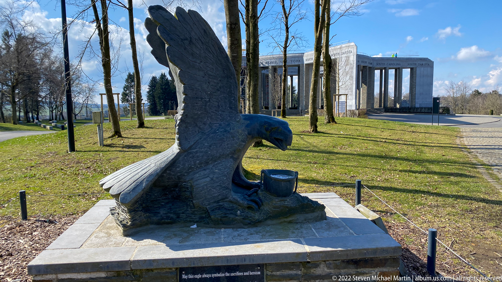
A large eagle sculpture with wings raised stands on a low stone plinth in the landscaped grounds near the Mardasson Memorial. The memorial’s pale colonnade appears beyond the trees, creating a visual relationship between the symbolic bird and the larger American commemorative complex. The close foreground viewpoint emphasizes the eagle’s spread feathers, lowered head, and commanding silhouette against the open lawn.
Caption
A large eagle sculpture with wings raised stands on a low stone plinth in the landscaped grounds near the Mardasson Memorial. The memorial’s pale colonnade appears beyond the trees, creating a visual relationship between the symbolic bird and the larger American commemorative complex. The close foreground viewpoint emphasizes the eagle’s spread feathers, lowered head, and commanding silhouette against the open lawn.

Viewed from across the approach road, the Mardasson Memorial presents its broad colonnaded ring and engraved state names as a freestanding monument. Scaffolding covers the left portion of the structure, documenting active maintenance or restoration. The open forecourt and low landscaping make the memorial's scale and horizontal profile especially clear against the sky.
Caption
Viewed from across the approach road, the Mardasson Memorial presents its broad colonnaded ring and engraved state names as a freestanding monument. Scaffolding covers the left portion of the structure, documenting active maintenance or restoration. The open forecourt and low landscaping make the memorial's scale and horizontal profile especially clear against the sky.

The Mardasson Memorial stands on a grassy rise near Bastogne, its monumental ring of pale stone columns and entablature silhouetted against a bright sky. Names of U.S. states are carved around the upper band, making the memorial's American dedication visually explicit. Scaffolding at one side records conservation or maintenance work underway when this view was made.
Caption
The Mardasson Memorial stands on a grassy rise near Bastogne, its monumental ring of pale stone columns and entablature silhouetted against a bright sky. Names of U.S. states are carved around the upper band, making the memorial's American dedication visually explicit. Scaffolding at one side records conservation or maintenance work underway when this view was made.

The entrance to the Bastogne War Museum is framed by a dark projecting canopy bearing the museum name above a glass vestibule. The modern façade and broad paved approach provide an exterior establishing view of the institution before the galleries, contrasting the building’s restrained contemporary design with the wartime material presented inside.
Caption
The entrance to the Bastogne War Museum is framed by a dark projecting canopy bearing the museum name above a glass vestibule. The modern façade and broad paved approach provide an exterior establishing view of the institution before the galleries, contrasting the building’s restrained contemporary design with the wartime material presented inside.
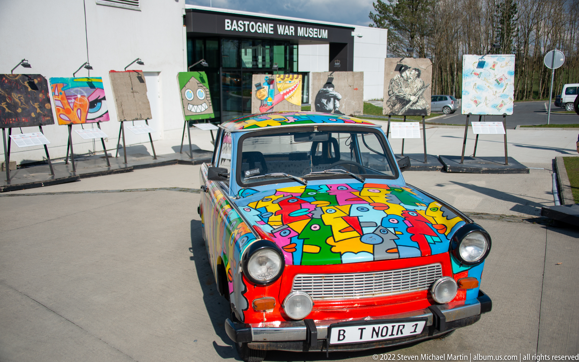
A brightly painted compact sedan stands directly in front of the Bastogne War Museum entrance, linking the decorated vehicle to the museum setting rather than isolating it as an abstract art object. Bold blocks of red, turquoise, yellow, and multicolored cartoon-like forms cover the hood and roof, while freestanding artworks line the plaza behind it.
Caption
A brightly painted compact sedan stands directly in front of the Bastogne War Museum entrance, linking the decorated vehicle to the museum setting rather than isolating it as an abstract art object. Bold blocks of red, turquoise, yellow, and multicolored cartoon-like forms cover the hood and roof, while freestanding artworks line the plaza behind it.
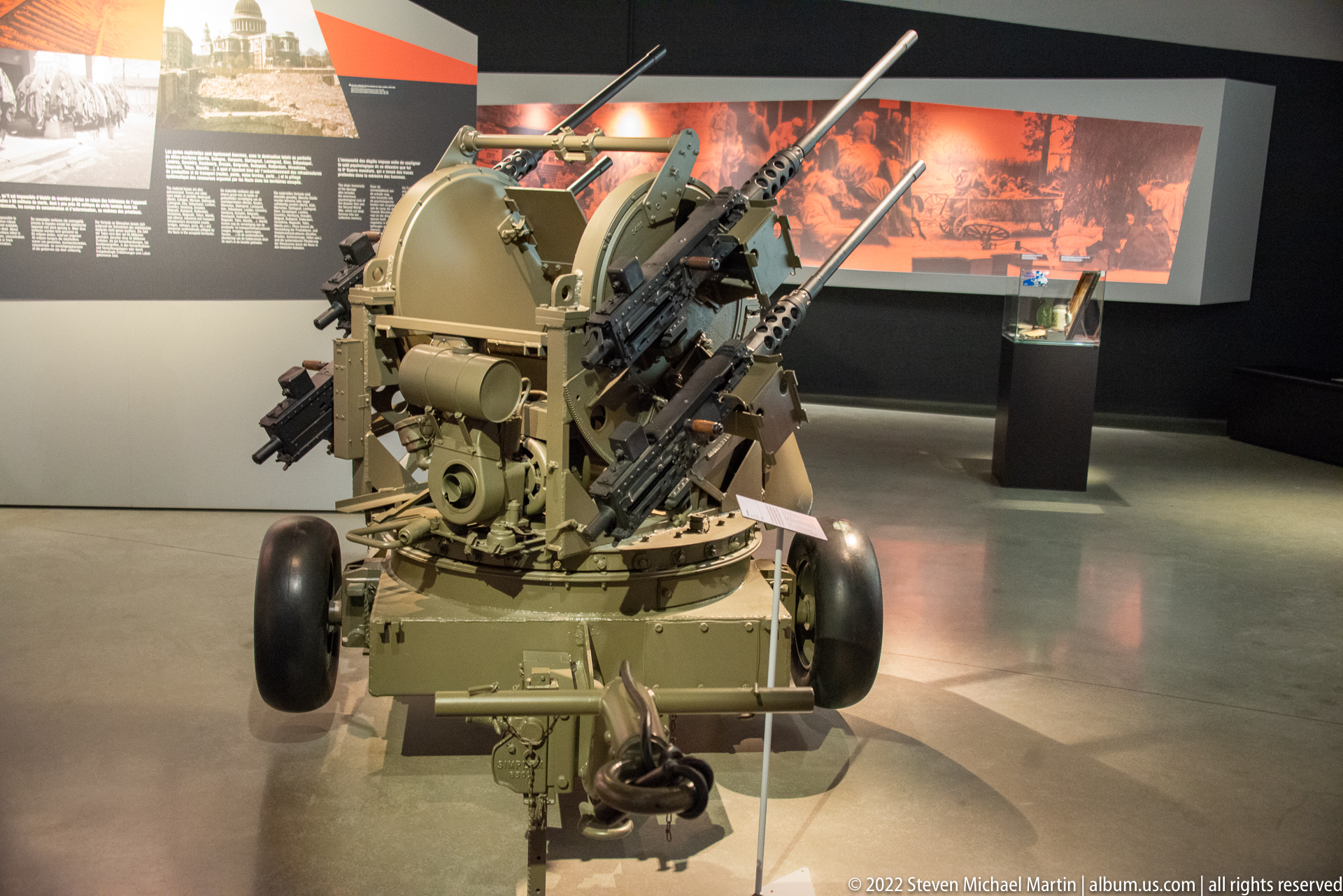
A restored, wheeled anti-aircraft gun is displayed as a freestanding artifact in the gallery, its clustered barrels elevated and its towing wheels and central mount fully visible. Seen head-on, the weapon's mechanical complexity dominates the composition, while a mural-like wartime backdrop provides historical context without obscuring the surviving hardware and its transportable field configuration.
Caption
A restored, wheeled anti-aircraft gun is displayed as a freestanding artifact in the gallery, its clustered barrels elevated and its towing wheels and central mount fully visible. Seen head-on, the weapon's mechanical complexity dominates the composition, while a mural-like wartime backdrop provides historical context without obscuring the surviving hardware and its transportable field configuration.
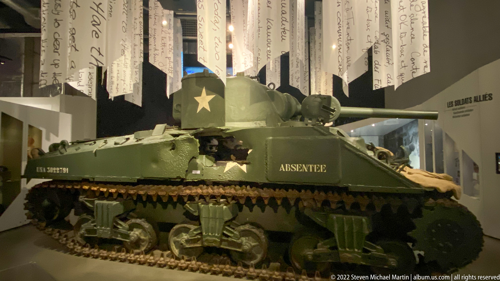
An American medium tank is displayed indoors beneath hanging strips carrying handwritten text, with a white star prominent on the turret and olive-drab armor throughout. The low hull, track system, turret, and long gun barrel dominate the gallery. The word “ABSENTEE” painted on the side gives the vehicle an individual identity within the museum presentation.
Caption
An American medium tank is displayed indoors beneath hanging strips carrying handwritten text, with a white star prominent on the turret and olive-drab armor throughout. The low hull, track system, turret, and long gun barrel dominate the gallery. The word “ABSENTEE” painted on the side gives the vehicle an individual identity within the museum presentation.

A curved interpretive wall assembles black-and-white wartime photographs above a red-toned lower band of additional images and captions. The sequence mixes soldiers, civilians, damaged buildings, and movement through towns, using a continuous visual timeline to introduce the conflict’s human and geographic context before individual artifacts are encountered.
Caption
A curved interpretive wall assembles black-and-white wartime photographs above a red-toned lower band of additional images and captions. The sequence mixes soldiers, civilians, damaged buildings, and movement through towns, using a continuous visual timeline to introduce the conflict’s human and geographic context before individual artifacts are encountered.

A U.S. Sherman tank displayed indoors carries a white Allied star on its hull and the name “BLOCKBUSTER” painted on the side. Seen from the front-left quarter, the photograph clearly shows the turret, main gun, suspension, tracks, and olive-drab finish, while wartime typography on the wall places the vehicle within the museum’s broader narrative of occupation and liberation.
Caption
A U.S. Sherman tank displayed indoors carries a white Allied star on its hull and the name “BLOCKBUSTER” painted on the side. Seen from the front-left quarter, the photograph clearly shows the turret, main gun, suspension, tracks, and olive-drab finish, while wartime typography on the wall places the vehicle within the museum’s broader narrative of occupation and liberation.
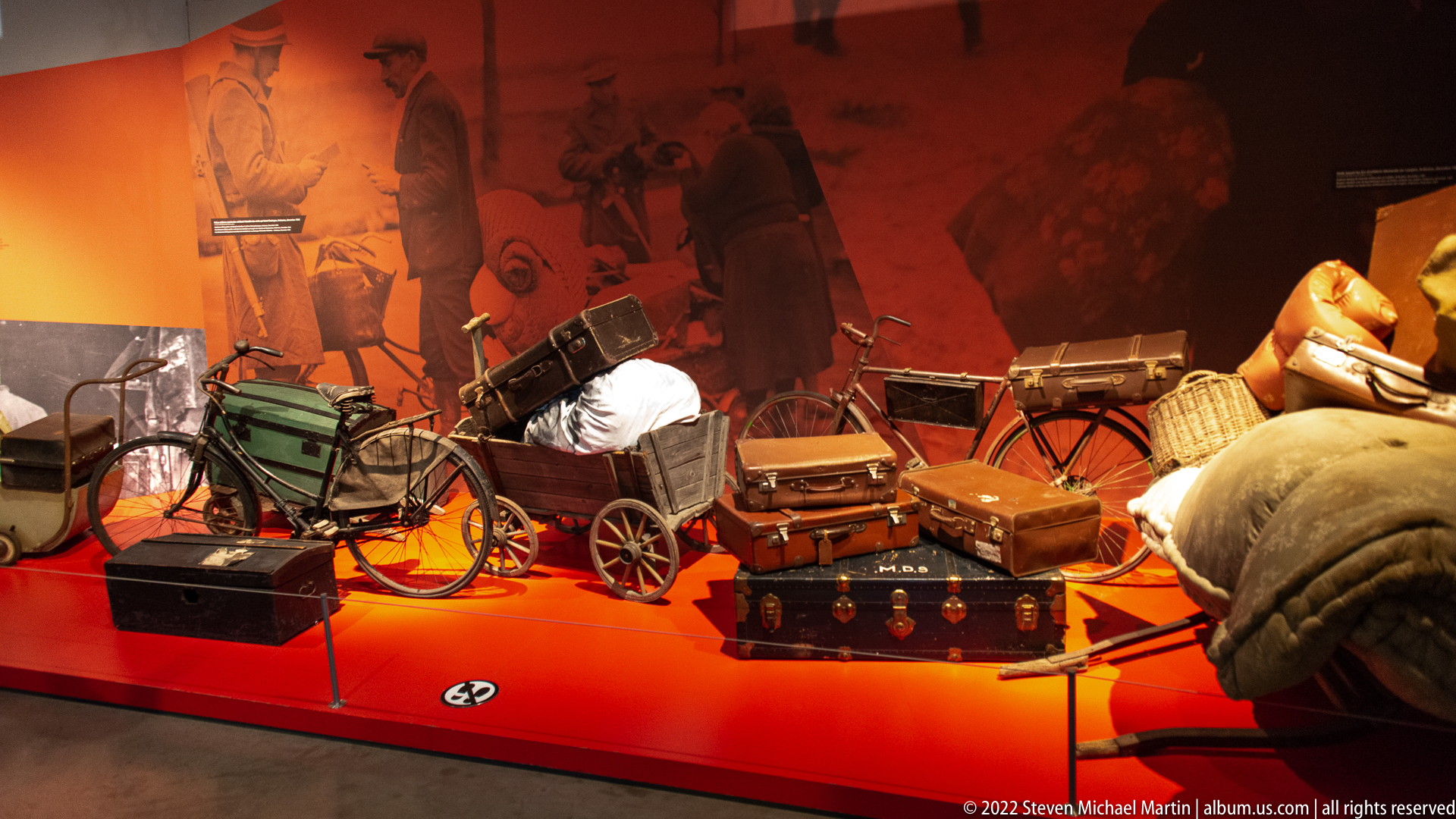
A staged display of bicycles, small handcarts, suitcases, trunks, baskets, bedding, and bundled belongings evokes civilian flight and displacement during wartime. The objects are crowded together on a red platform before enlarged historical imagery, emphasizing the practical burden of carrying essential possessions when leaving home under emergency conditions.
Caption
A staged display of bicycles, small handcarts, suitcases, trunks, baskets, bedding, and bundled belongings evokes civilian flight and displacement during wartime. The objects are crowded together on a red platform before enlarged historical imagery, emphasizing the practical burden of carrying essential possessions when leaving home under emergency conditions.

A museum identity panel combines the name Bastogne War Museum with the phrase “Living Memory of the Ardennes” beneath a stylized white building silhouette and star emblem. Reflections of sky and interior lights cross the glossy surface, making this a graphic detail rather than an exterior architectural view.
Caption
A museum identity panel combines the name Bastogne War Museum with the phrase “Living Memory of the Ardennes” beneath a stylized white building silhouette and star emblem. Reflections of sky and interior lights cross the glossy surface, making this a graphic detail rather than an exterior architectural view.
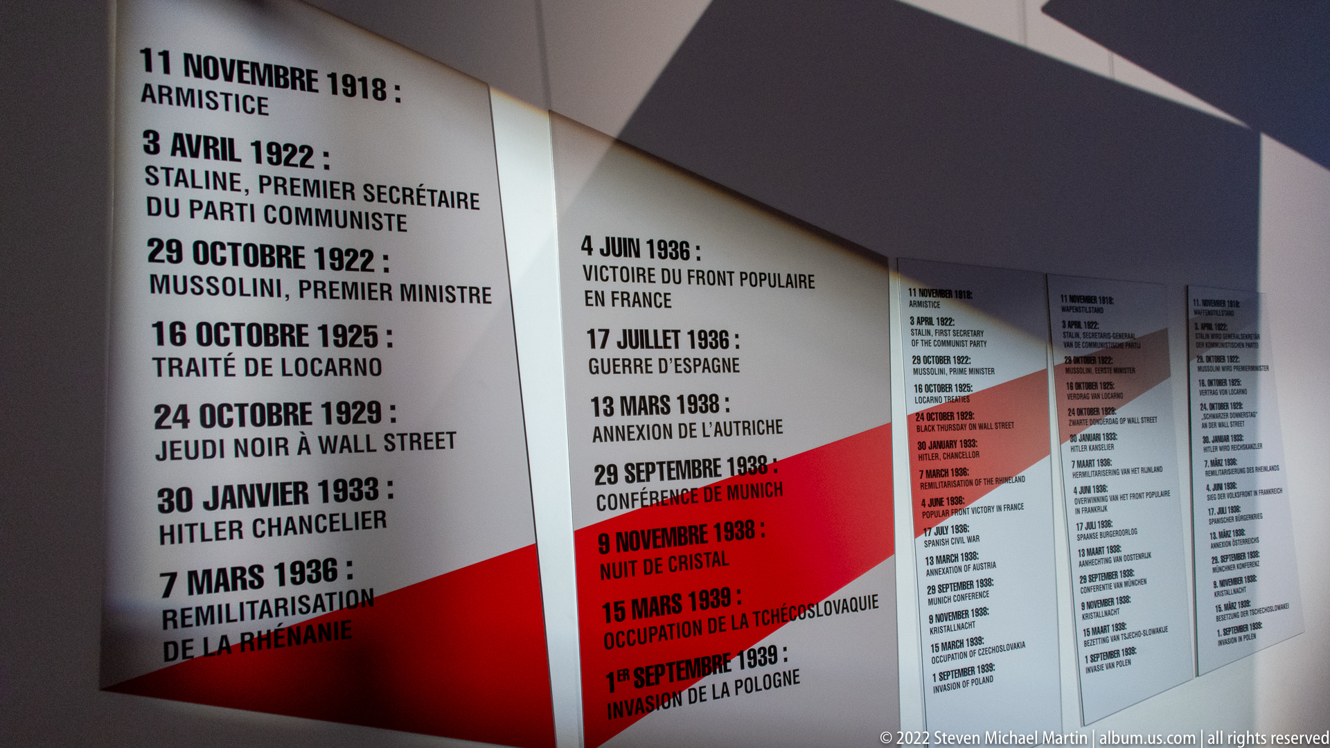
An illuminated chronology panel lists major European political events between the world wars, including references to Stalin, Mussolini, Hitler, remilitarization, and the Munich conference. Tall white, gray, and red columns organize dates and events into parallel sequences, showing how the museum frames the road to the Second World War through a documentary timeline.
Caption
An illuminated chronology panel lists major European political events between the world wars, including references to Stalin, Mussolini, Hitler, remilitarization, and the Munich conference. Tall white, gray, and red columns organize dates and events into parallel sequences, showing how the museum frames the road to the Second World War through a documentary timeline.
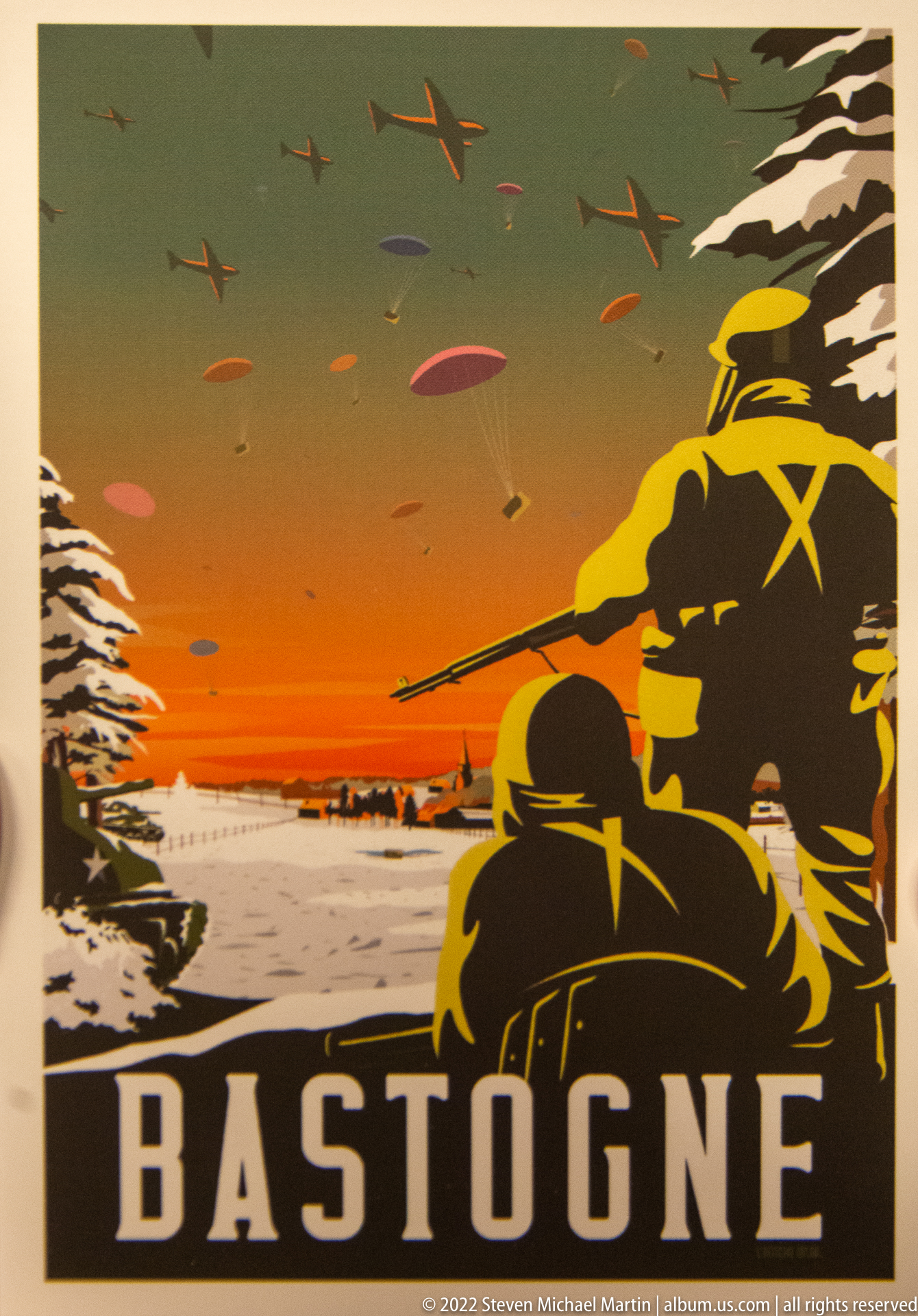
A vivid poster-style graphic presents helmeted soldiers in silhouette against an orange winter sky, with aircraft overhead and the place name “BASTOGNE” in large block letters below. The simplified forms and limited palette evoke wartime propaganda and commemorative design, emphasizing the town’s military associations rather than documenting a specific battlefield scene.
Caption
A vivid poster-style graphic presents helmeted soldiers in silhouette against an orange winter sky, with aircraft overhead and the place name “BASTOGNE” in large block letters below. The simplified forms and limited palette evoke wartime propaganda and commemorative design, emphasizing the town’s military associations rather than documenting a specific battlefield scene.

A large interpretive map titled around Europe’s minorities in 1923 uses contrasting colors, hatching, and boundary lines to show postwar states and contested or mixed regions across Central and Eastern Europe. The visual emphasizes how borders, minority populations, and territorial arrangements after the First World War formed part of the political landscape preceding the next conflict.
Caption
A large interpretive map titled around Europe’s minorities in 1923 uses contrasting colors, hatching, and boundary lines to show postwar states and contested or mixed regions across Central and Eastern Europe. The visual emphasizes how borders, minority populations, and territorial arrangements after the First World War formed part of the political landscape preceding the next conflict.

A glass display case gathers personal papers, photographs, booklets, insignia, small containers, a cap, and a sheathed edged tool around a red swastika armband. The mixed documentary and personal objects create an archival assemblage associated with Nazi-era civilian or military life, but the proof sheet does not provide enough detail to assign individual owners or exact functions to every item.
Caption
A glass display case gathers personal papers, photographs, booklets, insignia, small containers, a cap, and a sheathed edged tool around a red swastika armband. The mixed documentary and personal objects create an archival assemblage associated with Nazi-era civilian or military life, but the proof sheet does not provide enough detail to assign individual owners or exact functions to every item.
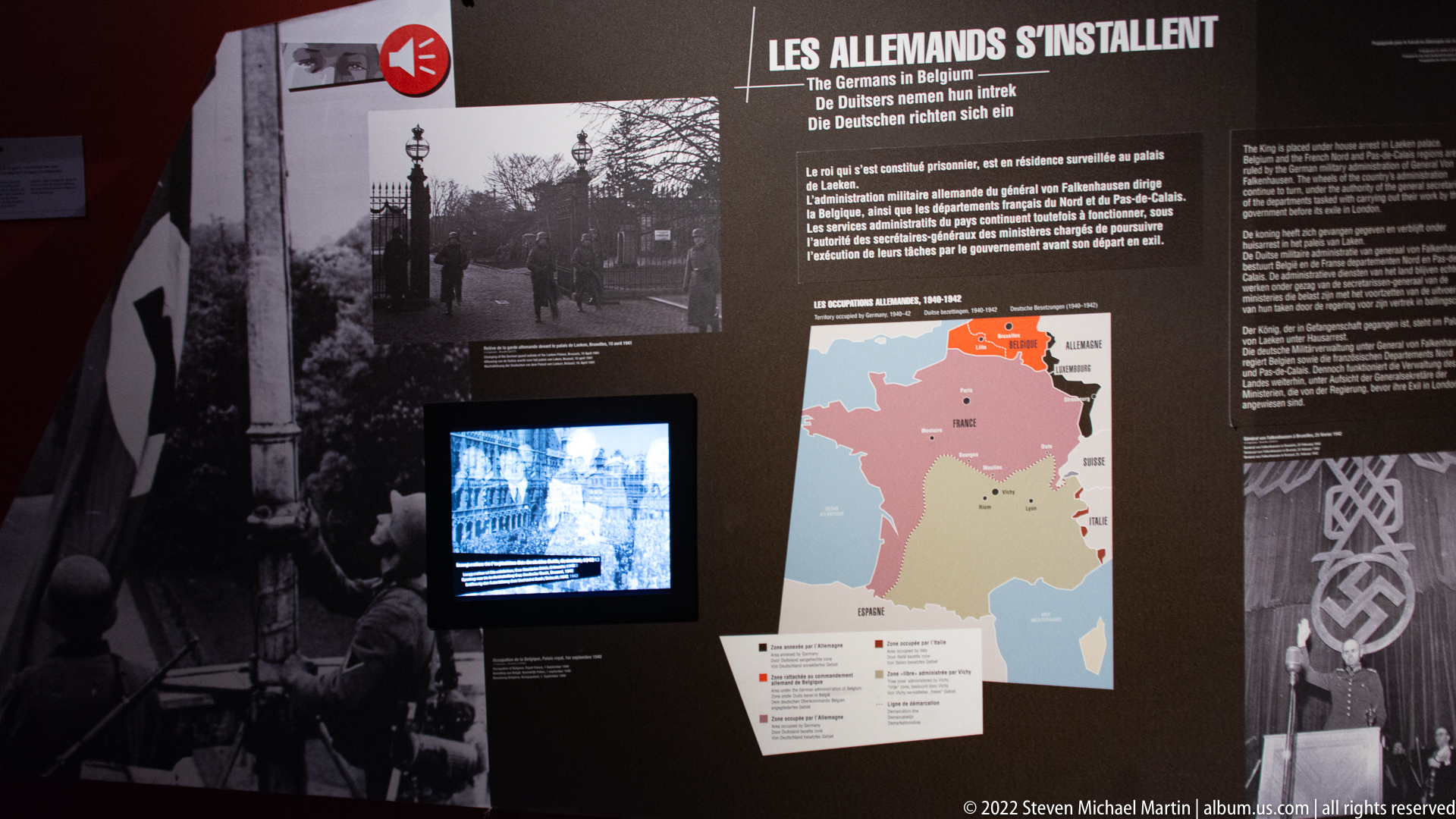
An exhibition panel headed “Les Allemands s’installent” explains the German occupation of Belgium through text, a map, historical photographs, and an embedded video screen. The dark graphic treatment and swastika imagery frame the transition from invasion to occupation, while the map situates events geographically for visitors moving through the chronology.
Caption
An exhibition panel headed “Les Allemands s’installent” explains the German occupation of Belgium through text, a map, historical photographs, and an embedded video screen. The dark graphic treatment and swastika imagery frame the transition from invasion to occupation, while the map situates events geographically for visitors moving through the chronology.

A close view of museum text describes the treatment of Belgian soldiers after the 1940 campaign, the occupation regime, imprisonment at Breendonk, persecution of political opponents, communists, and Jews, and deportations from Mechelen. The photograph is primarily documentary, preserving the exhibition’s English-language narrative rather than a separate artifact or visual object.
Caption
A close view of museum text describes the treatment of Belgian soldiers after the 1940 campaign, the occupation regime, imprisonment at Breendonk, persecution of political opponents, communists, and Jews, and deportations from Mechelen. The photograph is primarily documentary, preserving the exhibition’s English-language narrative rather than a separate artifact or visual object.
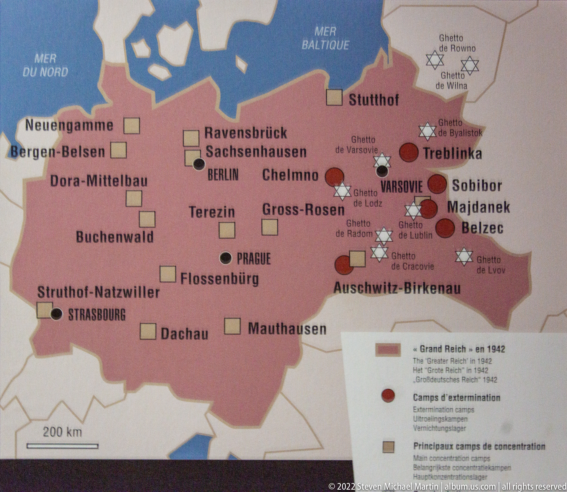
A map of Nazi-controlled Europe marks major concentration and extermination camps, including Auschwitz-Birkenau, Treblinka, Sobibor, Belzec, Majdanek, Dachau, Buchenwald, and others. Symbols and a legend distinguish camp categories within the Greater German Reich and occupied territories, presenting the geographic scale of imprisonment and mass murder across Europe.
Caption
A map of Nazi-controlled Europe marks major concentration and extermination camps, including Auschwitz-Birkenau, Treblinka, Sobibor, Belzec, Majdanek, Dachau, Buchenwald, and others. Symbols and a legend distinguish camp categories within the Greater German Reich and occupied territories, presenting the geographic scale of imprisonment and mass murder across Europe.

A world map uses red shading, arrows, and concentric route lines to summarize Axis expansion and major theaters of the Second World War. Europe and East Asia are emphasized, with movement shown across the Atlantic, Pacific, North Africa, and Asia, giving visitors a global frame for the more localized story of Belgium and the Ardennes.
Caption
A world map uses red shading, arrows, and concentric route lines to summarize Axis expansion and major theaters of the Second World War. Europe and East Asia are emphasized, with movement shown across the Atlantic, Pacific, North Africa, and Asia, giving visitors a global frame for the more localized story of Belgium and the Ardennes.

A detailed campaign map of Normandy plots Allied beachheads, unit movements, and German positions during the 1944 invasion and breakout. Place names such as Caen, Avranches, Falaise, and Cherbourg appear amid dense tactical arrows and unit labels, turning the coastline into a compact operational overview of the fighting that followed D-Day.
Caption
A detailed campaign map of Normandy plots Allied beachheads, unit movements, and German positions during the 1944 invasion and breakout. Place names such as Caen, Avranches, Falaise, and Cherbourg appear amid dense tactical arrows and unit labels, turning the coastline into a compact operational overview of the fighting that followed D-Day.

A gallery section centered on “6 Juin 1944” combines enlarged photographs of airborne troops, landing forces, aircraft, ships, and battlefield scenes with text, a campaign map, and a small screen. The cool gray exhibition design presents D-Day through multiple visual sources, linking the landings to the broader Allied return to Western Europe.
Caption
A gallery section centered on “6 Juin 1944” combines enlarged photographs of airborne troops, landing forces, aircraft, ships, and battlefield scenes with text, a campaign map, and a small screen. The cool gray exhibition design presents D-Day through multiple visual sources, linking the landings to the broader Allied return to Western Europe.
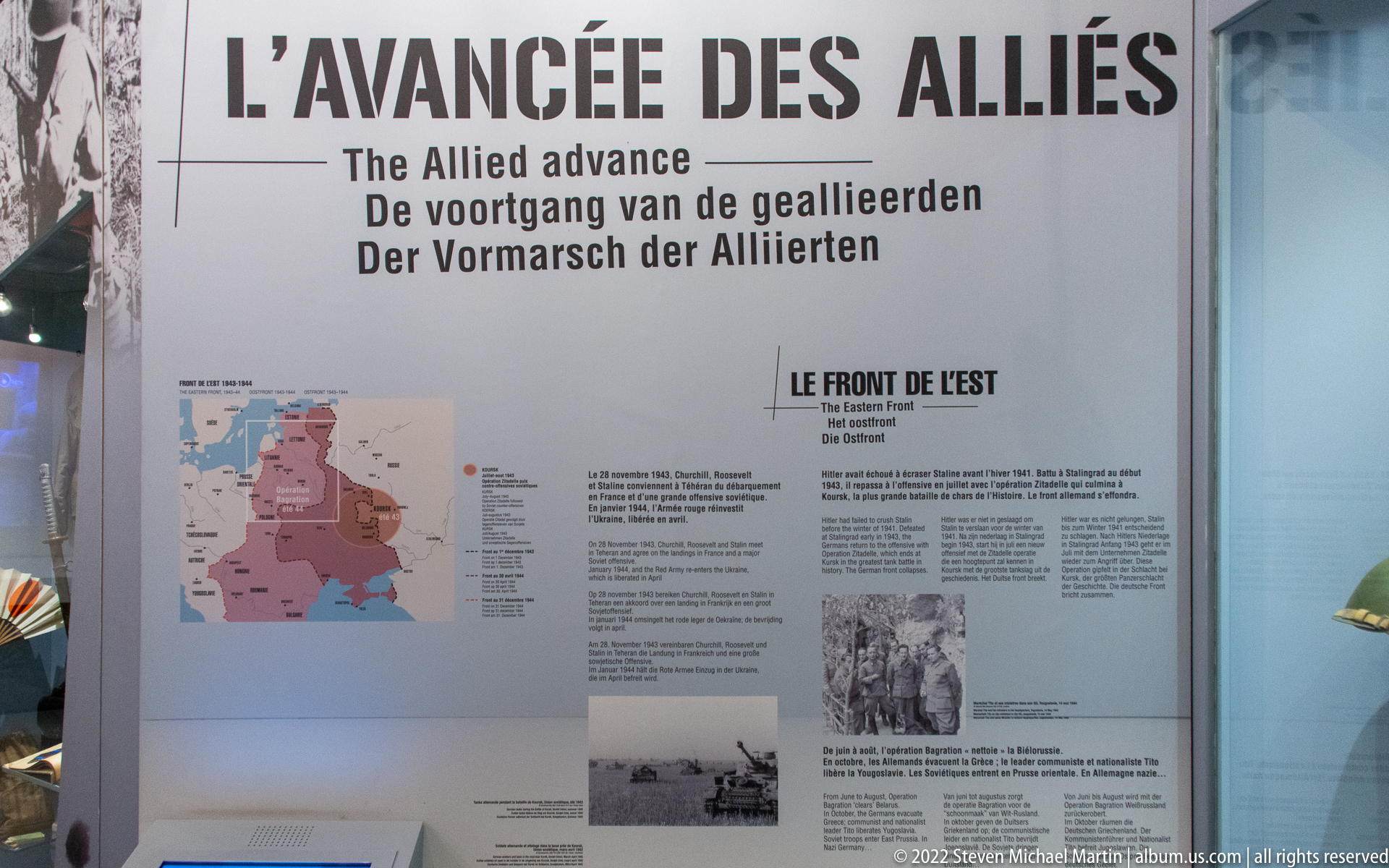
A tall panel headed “L’Avancée des Alliés” traces the Allied advance after the Normandy campaign. A colored map, explanatory text, and wartime photographs summarize movement on the western and eastern fronts, presenting the liberation of occupied territory as a shifting military geography rather than a single event or battlefield.
Caption
A tall panel headed “L’Avancée des Alliés” traces the Allied advance after the Normandy campaign. A colored map, explanatory text, and wartime photographs summarize movement on the western and eastern fronts, presenting the liberation of occupied territory as a shifting military geography rather than a single event or battlefield.
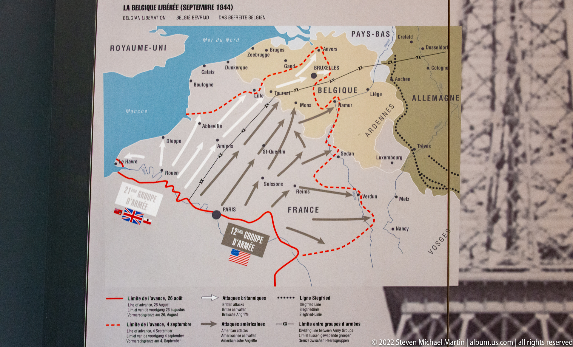
A museum map titled “La Belgique libérée (septembre 1944)” charts Allied routes into Belgium with broad arrows, dated lines, and geographic references spanning northern France, Belgium, the Netherlands, Germany, and Luxembourg. The composition shows the rapid advance as a sequence of movements and front lines, setting the geographic context for the later Ardennes fighting.
Caption
A museum map titled “La Belgique libérée (septembre 1944)” charts Allied routes into Belgium with broad arrows, dated lines, and geographic references spanning northern France, Belgium, the Netherlands, Germany, and Luxembourg. The composition shows the rapid advance as a sequence of movements and front lines, setting the geographic context for the later Ardennes fighting.
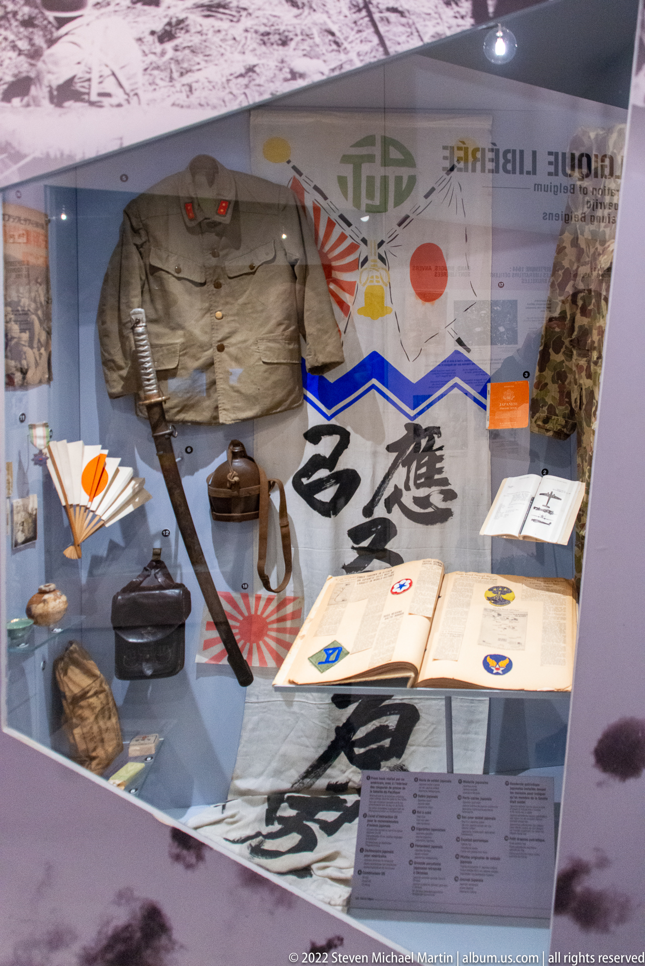
A display case groups Imperial Japanese military material beneath the rising-sun motif, including uniforms, cloth insignia or banners, headgear, documents, and personal equipment. The artifacts are arranged as a dense material-culture ensemble, with calligraphic textiles and printed records providing a visual counterpoint to the European campaigns covered in adjacent galleries.
Caption
A display case groups Imperial Japanese military material beneath the rising-sun motif, including uniforms, cloth insignia or banners, headgear, documents, and personal equipment. The artifacts are arranged as a dense material-culture ensemble, with calligraphic textiles and printed records providing a visual counterpoint to the European campaigns covered in adjacent galleries.
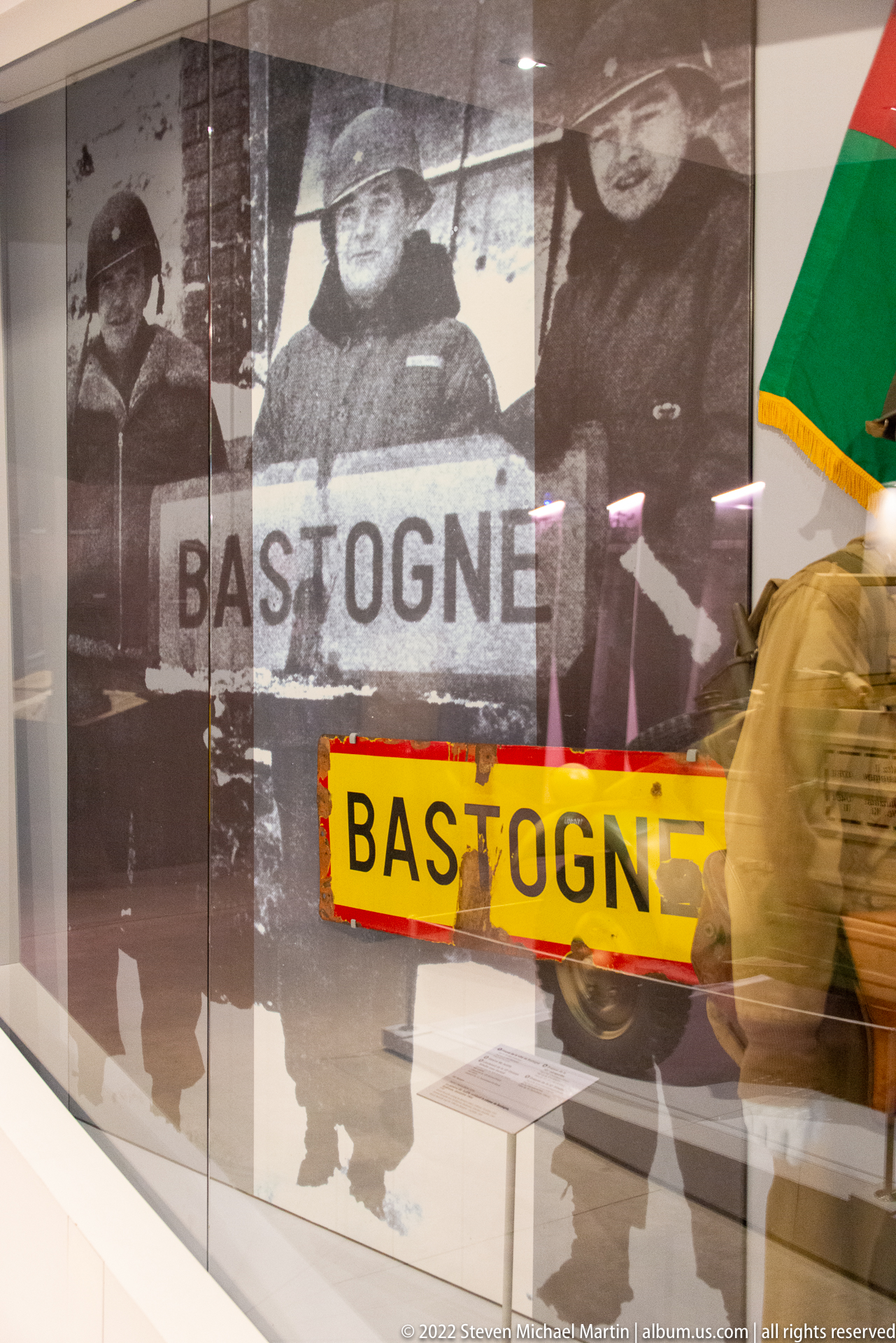
A bright yellow-and-red road sign reading “BASTOGNE” is displayed before an enlarged photograph of soldiers holding a Bastogne sign, visually linking an original or period-style traffic marker with wartime memory. A uniformed figure and other artifacts appear nearby, but the sign’s bold lettering and direct place-name association dominate the composition.
Caption
A bright yellow-and-red road sign reading “BASTOGNE” is displayed before an enlarged photograph of soldiers holding a Bastogne sign, visually linking an original or period-style traffic marker with wartime memory. A uniformed figure and other artifacts appear nearby, but the sign’s bold lettering and direct place-name association dominate the composition.

A painted commemorative road marker bears the French words “VOIE DE LIBERTE,” the number 1147, and the date 1947, with a red torch motif rising above stylized blue waves. The object evokes the postwar memorial route associated with the Allied advance through liberated France and Belgium, presented here as a compact piece of commemorative design within the museum collection.
Caption
A painted commemorative road marker bears the French words “VOIE DE LIBERTE,” the number 1147, and the date 1947, with a red torch motif rising above stylized blue waves. The object evokes the postwar memorial route associated with the Allied advance through liberated France and Belgium, presented here as a compact piece of commemorative design within the museum collection.

A compact U.S. military jeep is displayed head-on with a white Allied star painted across the hood and stenciled registration markings on the bumper. Its upright slotted grille, round headlights, flat windshield, and narrow body show the utilitarian form that made the jeep a ubiquitous light vehicle for transport, liaison, and field duties during the war.
Caption
A compact U.S. military jeep is displayed head-on with a white Allied star painted across the hood and stenciled registration markings on the bumper. Its upright slotted grille, round headlights, flat windshield, and narrow body show the utilitarian form that made the jeep a ubiquitous light vehicle for transport, liaison, and field duties during the war.

A large black swastika within a white circle dominates a red exhibition wall, towering over several small artifact cases and wartime photographs. The installation uses the emblem as a stark visual marker for Nazi Germany, while the surrounding objects and images shift attention from political symbolism toward the material evidence preserved in the museum collection.
Caption
A large black swastika within a white circle dominates a red exhibition wall, towering over several small artifact cases and wartime photographs. The installation uses the emblem as a stark visual marker for Nazi Germany, while the surrounding objects and images shift attention from political symbolism toward the material evidence preserved in the museum collection.
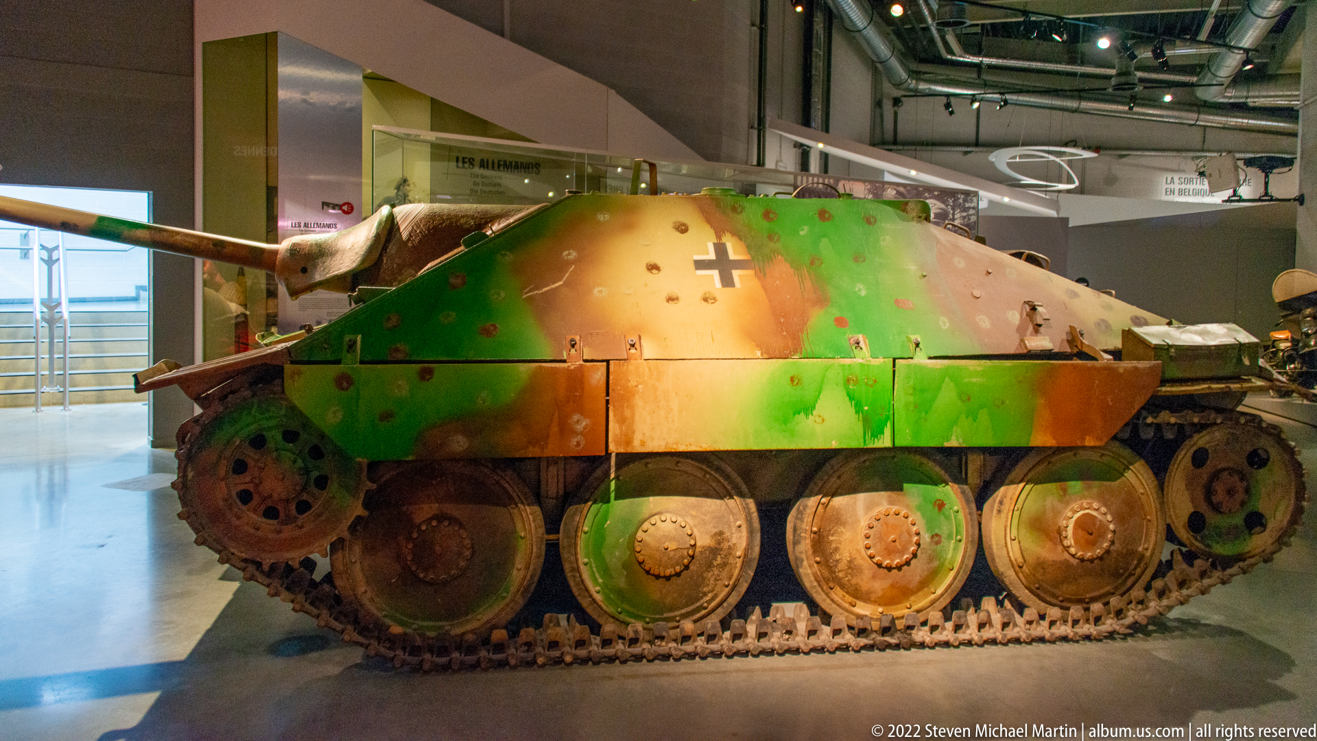
A German Jagdpanzer 38(t), commonly known as the Hetzer, fills the gallery in a low side profile. Its sharply sloped armored hull, offset gun, compact tracked chassis, and mottled green-brown camouflage are clearly visible, along with a German cross on the upper side. The close view emphasizes the vehicle’s distinctive casemate form rather than a conventional rotating turret.
Caption
A German Jagdpanzer 38(t), commonly known as the Hetzer, fills the gallery in a low side profile. Its sharply sloped armored hull, offset gun, compact tracked chassis, and mottled green-brown camouflage are clearly visible, along with a German cross on the upper side. The close view emphasizes the vehicle’s distinctive casemate form rather than a conventional rotating turret.

Two German military uniforms stand in a glass case beneath the heading “Les 2 QG Rivaux,” backed by portraits and labels identifying command figures. One mannequin wears a brown field-style uniform and the other a darker officer’s coat and peaked cap, presenting clothing and command imagery together within an exhibit on opposing headquarters.
Caption
Two German military uniforms stand in a glass case beneath the heading “Les 2 QG Rivaux,” backed by portraits and labels identifying command figures. One mannequin wears a brown field-style uniform and the other a darker officer’s coat and peaked cap, presenting clothing and command imagery together within an exhibit on opposing headquarters.

A large operational map presents the Ardennes battle area across Belgium, Luxembourg, and western Germany using front lines, unit symbols, arrows, and a dense explanatory legend. The central brown-shaded salient and surrounding labels translate a complex military situation into a single strategic view, with Bastogne positioned within the wider German offensive and Allied response.
Caption
A large operational map presents the Ardennes battle area across Belgium, Luxembourg, and western Germany using front lines, unit symbols, arrows, and a dense explanatory legend. The central brown-shaded salient and surrounding labels translate a complex military situation into a single strategic view, with Bastogne positioned within the wider German offensive and Allied response.

A German Volkswagen Kübelwagen is displayed three-quarter front view with camouflage paint, a rear-mounted spare tire, open passenger compartment, and simple slab-sided bodywork. The light utility vehicle’s exposed fenders and high ground clearance reflect its field-oriented design, while museum barriers and an information stand identify it as a preserved artifact rather than a reconstruction in use.
Caption
A German Volkswagen Kübelwagen is displayed three-quarter front view with camouflage paint, a rear-mounted spare tire, open passenger compartment, and simple slab-sided bodywork. The light utility vehicle’s exposed fenders and high ground clearance reflect its field-oriented design, while museum barriers and an information stand identify it as a preserved artifact rather than a reconstruction in use.
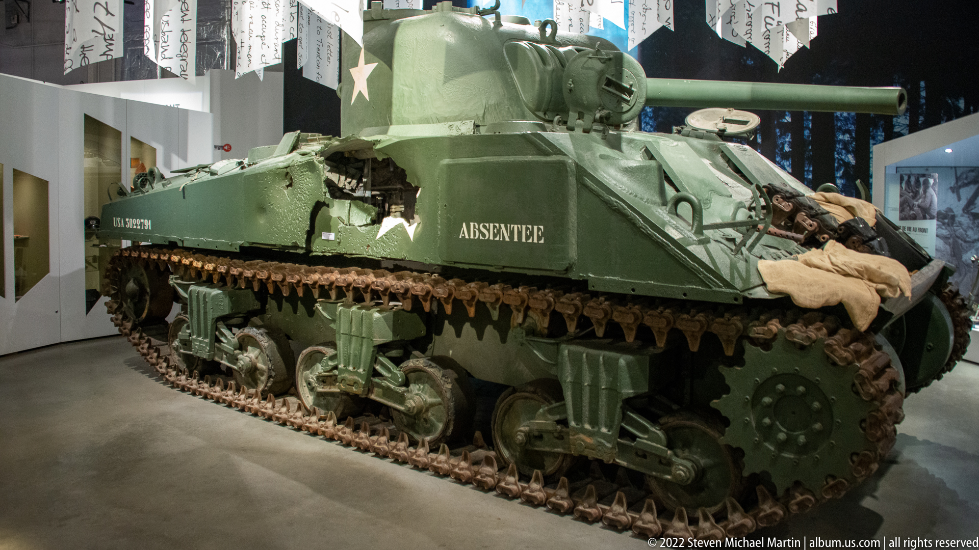
A U.S. Sherman tank named “ABSENTEE” is shown from the front-left side in the museum gallery, its white Allied star, turret, main gun, tracks, and suspension clearly visible. Packs and fabric gear are draped around the hull, giving the display a field-loaded appearance and distinguishing this vehicle from the cleaner Sherman presentation elsewhere in the museum.
Caption
A U.S. Sherman tank named “ABSENTEE” is shown from the front-left side in the museum gallery, its white Allied star, turret, main gun, tracks, and suspension clearly visible. Packs and fabric gear are draped around the hull, giving the display a field-loaded appearance and distinguishing this vehicle from the cleaner Sherman presentation elsewhere in the museum.
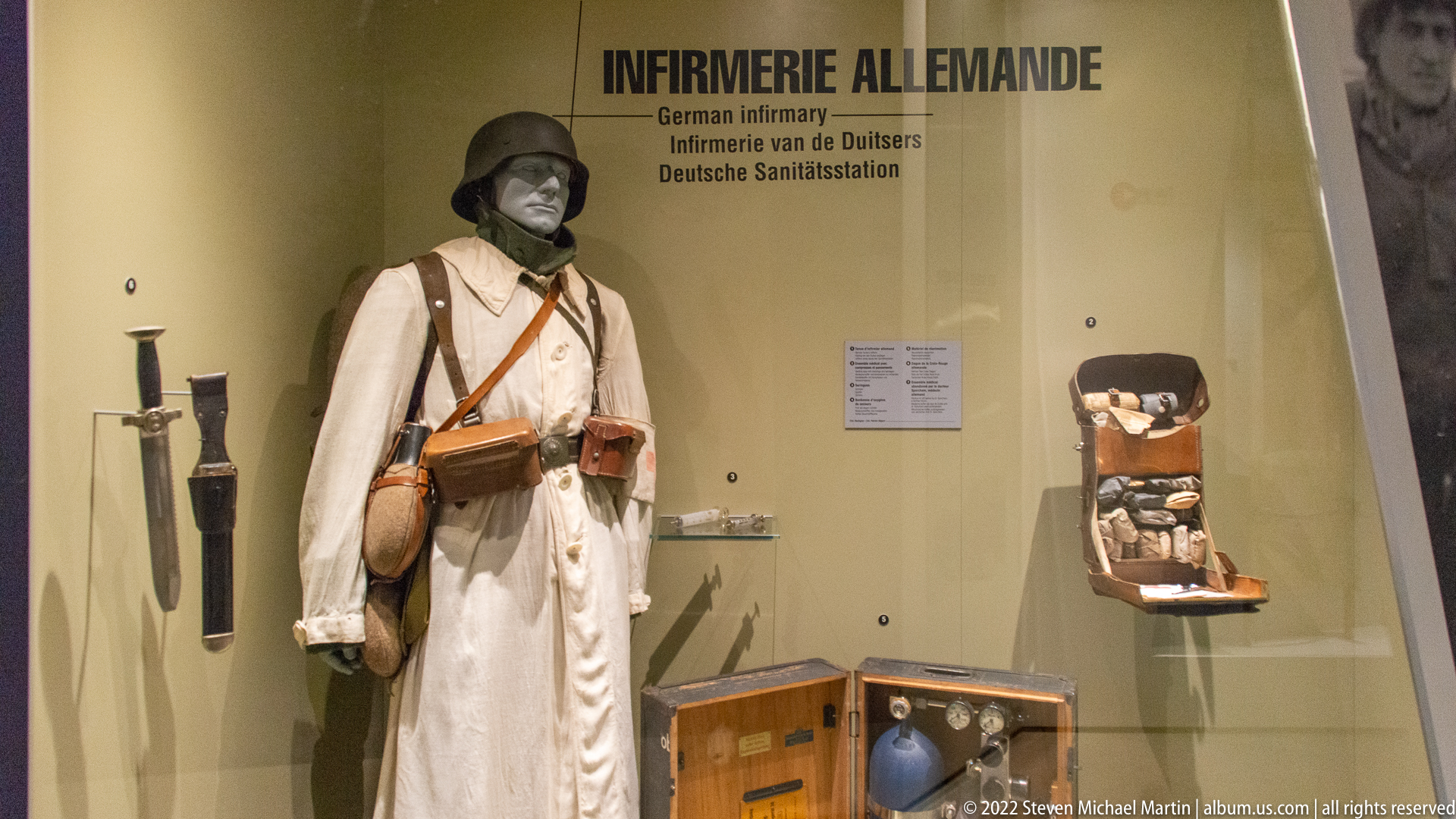
A mannequin in winter military clothing stands beside field medical equipment under the bilingual heading “Infirmerie Allemande / German Infirmary.” White outer garments, a steel helmet, leather pouches, tools, small containers, and boxed supplies reconstruct the material setting of a German medical station, focusing on treatment equipment rather than combat weaponry.
Caption
A mannequin in winter military clothing stands beside field medical equipment under the bilingual heading “Infirmerie Allemande / German Infirmary.” White outer garments, a steel helmet, leather pouches, tools, small containers, and boxed supplies reconstruct the material setting of a German medical station, focusing on treatment equipment rather than combat weaponry.

An open ledger filled with handwritten entries is displayed beneath loose forms, notes, and a small knitted or fur-like fragment placed across the pages. The overlapping documents suggest an archival grouping of wartime records and personal material, but the proof-sheet resolution does not support a secure reading of names, dates, or the precise administrative purpose of the book.
Caption
An open ledger filled with handwritten entries is displayed beneath loose forms, notes, and a small knitted or fur-like fragment placed across the pages. The overlapping documents suggest an archival grouping of wartime records and personal material, but the proof-sheet resolution does not support a secure reading of names, dates, or the precise administrative purpose of the book.

Rows of simplified white grave-marker forms stand before mirrored walls, creating repeated reflections that multiply the memorial shapes into the distance. Small digital screens sit at the bases of several markers, turning the installation into an interactive commemorative space rather than a conventional artifact case and emphasizing repetition, absence, and remembrance through the gallery design itself.
Caption
Rows of simplified white grave-marker forms stand before mirrored walls, creating repeated reflections that multiply the memorial shapes into the distance. Small digital screens sit at the bases of several markers, turning the installation into an interactive commemorative space rather than a conventional artifact case and emphasizing repetition, absence, and remembrance through the gallery design itself.
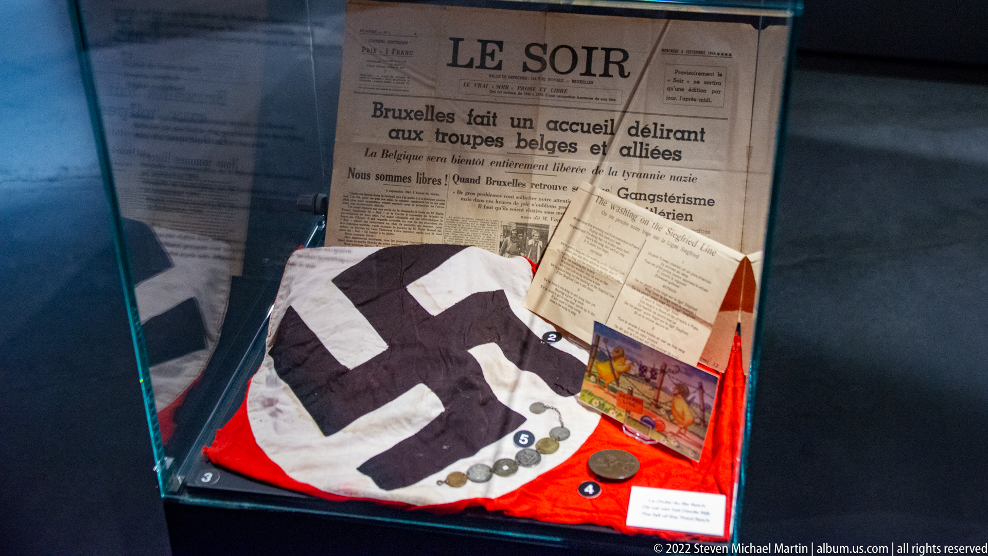
A compact case brings together a copy of the Belgian newspaper Le Soir, printed notices, a folded swastika flag or banner, coins or medals, and colorful paper souvenirs. The juxtaposition of Nazi symbolism with a headline welcoming Belgian and Allied troops frames the display around occupation ending and liberation, while preserving the small everyday documents through which those events were recorded.
Caption
A compact case brings together a copy of the Belgian newspaper Le Soir, printed notices, a folded swastika flag or banner, coins or medals, and colorful paper souvenirs. The juxtaposition of Nazi symbolism with a headline welcoming Belgian and Allied troops frames the display around occupation ending and liberation, while preserving the small everyday documents through which those events were recorded.

Large bilingual museum panel combines wartime photographs, a ruined urban landscape, marching civilians or prisoners, and a prominent image of a domed building. The red-and-black graphic treatment organizes text and archival imagery into a thematic section addressing the human and material consequences of war, placing individual experience within the wider destruction of Europe.
Caption
Large bilingual museum panel combines wartime photographs, a ruined urban landscape, marching civilians or prisoners, and a prominent image of a domed building. The red-and-black graphic treatment organizes text and archival imagery into a thematic section addressing the human and material consequences of war, placing individual experience within the wider destruction of Europe.

Two adjacent interpretive sections trace the collapse of Nazi Germany at the end of the Second World War. One uses newspaper front pages announcing Hitler's death, while the neighboring panel presents a crowded surrender scene under the heading concerning Germany's capitulation. The display relies on period press imagery and documentary photographs to mark the transition from dictatorship and war to defeat.
Caption
Two adjacent interpretive sections trace the collapse of Nazi Germany at the end of the Second World War. One uses newspaper front pages announcing Hitler's death, while the neighboring panel presents a crowded surrender scene under the heading concerning Germany's capitulation. The display relies on period press imagery and documentary photographs to mark the transition from dictatorship and war to defeat.

A museum panel headed “LE PROCÈS DE NUREMBERG” pairs courtroom photography with explanatory text about the postwar prosecution of Nazi leaders. A second heading introduces the new geopolitical order of the Cold War between East and West. The layout links judicial reckoning with the rapid reorganization of Europe after 1945, using photographs and text as successive historical chapters.
Caption
A museum panel headed “LE PROCÈS DE NUREMBERG” pairs courtroom photography with explanatory text about the postwar prosecution of Nazi leaders. A second heading introduces the new geopolitical order of the Cold War between East and West. The layout links judicial reckoning with the rapid reorganization of Europe after 1945, using photographs and text as successive historical chapters.

A visitor studies an outdoor interpretive panel in the landscaped grounds beside the Mardasson Memorial. The memorial's pale colonnade rises beyond the sloping lawn, while the panel combines historic photographs, text, and a map. The scene records how the site presents the Battle of the Bulge through both monumental architecture and on-site historical interpretation.
Caption
A visitor studies an outdoor interpretive panel in the landscaped grounds beside the Mardasson Memorial. The memorial's pale colonnade rises beyond the sloping lawn, while the panel combines historic photographs, text, and a map. The scene records how the site presents the Battle of the Bulge through both monumental architecture and on-site historical interpretation.
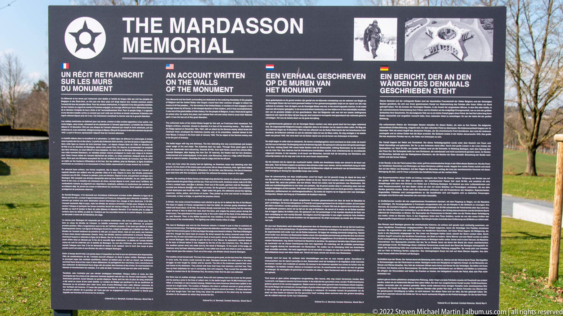
A large multilingual sign titled “THE MARDASSON MEMORIAL” explains the monument and its commemorative program. Dense columns of text are paired with small historic illustrations, presenting the memorial as both a physical place and a written record of remembrance. The surrounding grass and trees situate the panel directly within the outdoor memorial complex.
Caption
A large multilingual sign titled “THE MARDASSON MEMORIAL” explains the monument and its commemorative program. Dense columns of text are paired with small historic illustrations, presenting the memorial as both a physical place and a written record of remembrance. The surrounding grass and trees situate the panel directly within the outdoor memorial complex.
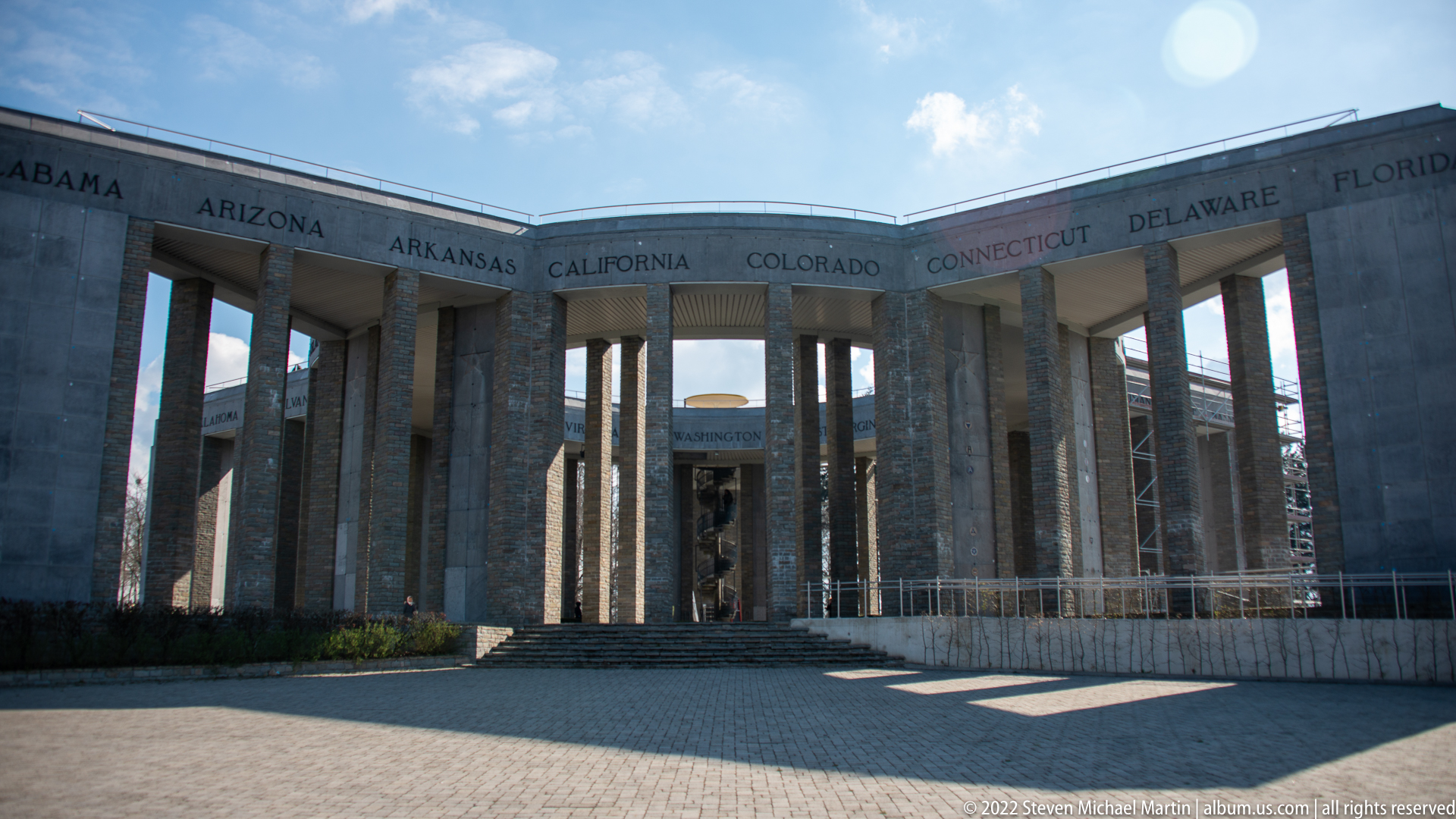
From inside the Mardasson Memorial, tall rectangular stone piers create a rhythmic semicircle around the open court. State names including Arizona, Arkansas, California, Colorado, Connecticut, Delaware, and Florida are carved along the entablature above. The low viewpoint emphasizes the memorial's encircling geometry and the repetitive vertical structure of its monumental colonnade.
Caption
From inside the Mardasson Memorial, tall rectangular stone piers create a rhythmic semicircle around the open court. State names including Arizona, Arkansas, California, Colorado, Connecticut, Delaware, and Florida are carved along the entablature above. The low viewpoint emphasizes the memorial's encircling geometry and the repetitive vertical structure of its monumental colonnade.

Another interior section of the Mardasson Memorial frames the wooded grounds through tall stone openings. The names Virginia, Washington, West Virginia, and Wisconsin appear across the upper ring, while clipped hedges occupy the foreground and a visitor supplies scale. This angle stresses the memorial's openness to the surrounding landscape as much as its massive masonry structure.
Caption
Another interior section of the Mardasson Memorial frames the wooded grounds through tall stone openings. The names Virginia, Washington, West Virginia, and Wisconsin appear across the upper ring, while clipped hedges occupy the foreground and a visitor supplies scale. This angle stresses the memorial's openness to the surrounding landscape as much as its massive masonry structure.

A close view isolates one of the Mardasson Memorial's carved dedicatory texts between rough-faced stone piers. The inscription commemorates American soldiers and thanks those who fought for freedom during the Battle of the Bulge. Weathered lettering and the upward camera angle emphasize the text as an integral architectural element rather than a separate plaque.
Caption
A close view isolates one of the Mardasson Memorial's carved dedicatory texts between rough-faced stone piers. The inscription commemorates American soldiers and thanks those who fought for freedom during the Battle of the Bulge. Weathered lettering and the upward camera angle emphasize the text as an integral architectural element rather than a separate plaque.
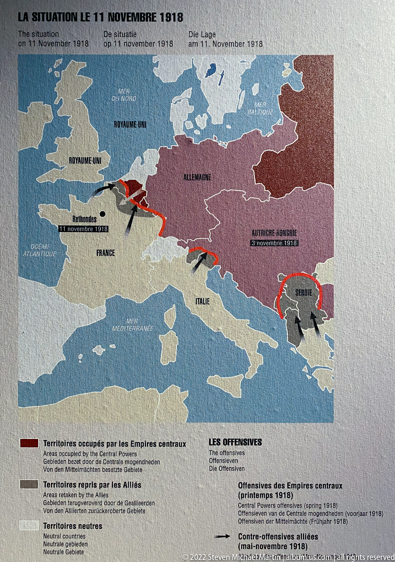
An interpretive map titled for the situation on 11 November 1918 charts the political and military geography of Europe at the close of the First World War. Red arrows and shaded regions mark major movements and spheres across the continent, while the accompanying legend distinguishes belligerent territories and postwar developments. The graphic introduces the unstable European order inherited by the interwar period.
Caption
An interpretive map titled for the situation on 11 November 1918 charts the political and military geography of Europe at the close of the First World War. Red arrows and shaded regions mark major movements and spheres across the continent, while the accompanying legend distinguishes belligerent territories and postwar developments. The graphic introduces the unstable European order inherited by the interwar period.

A map headed for the Treaty of Versailles in 1919 illustrates the redrawing of Europe after the First World War. Germany and neighboring territories are shaded to show borders and territorial changes, while explanatory text below discusses disarmament, occupation, and the postwar settlement. The panel presents the treaty geographically, emphasizing how political decisions were inscribed onto the map of Europe.
Caption
A map headed for the Treaty of Versailles in 1919 illustrates the redrawing of Europe after the First World War. Germany and neighboring territories are shaded to show borders and territorial changes, while explanatory text below discusses disarmament, occupation, and the postwar settlement. The panel presents the treaty geographically, emphasizing how political decisions were inscribed onto the map of Europe.
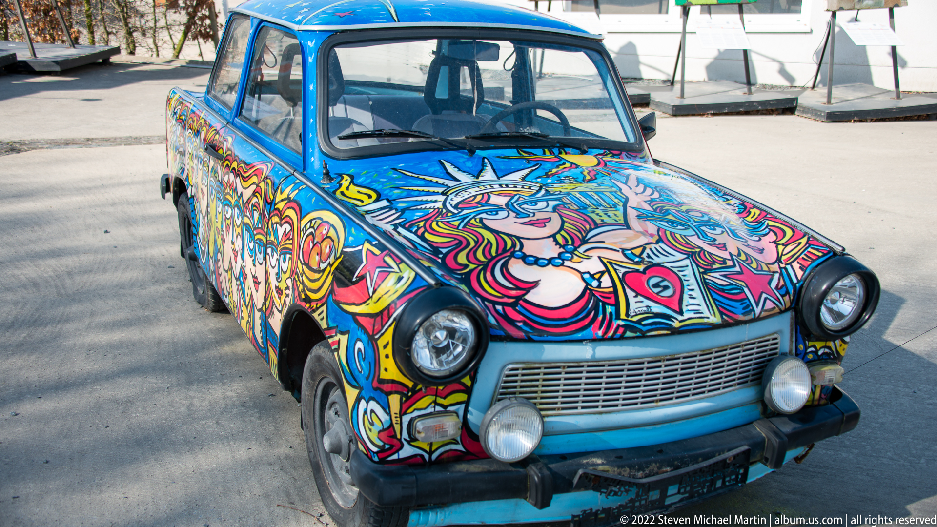
A small East German-style sedan is covered in dense psychedelic and pop-art painting, with stylized faces, flowers, eyes, and brightly outlined motifs wrapping across the hood and body. The car has been transformed from transportation into a mobile art object, using a familiar Cold War-era vehicle form as the support for exuberant contemporary decoration.
Caption
A small East German-style sedan is covered in dense psychedelic and pop-art painting, with stylized faces, flowers, eyes, and brightly outlined motifs wrapping across the hood and body. The car has been transformed from transportation into a mobile art object, using a familiar Cold War-era vehicle form as the support for exuberant contemporary decoration.

A second decorated compact car combines turquoise and yellow bodywork with portrait imagery, peace-themed graphics, and painted text across the hood and front fenders. Its improvised, hand-painted surface turns an austere Cold War-era vehicle into a bright commemorative artifact. Outdoor display panels and artworks behind it create the atmosphere of a temporary or interpretive installation.
Caption
A second decorated compact car combines turquoise and yellow bodywork with portrait imagery, peace-themed graphics, and painted text across the hood and front fenders. Its improvised, hand-painted surface turns an austere Cold War-era vehicle into a bright commemorative artifact. Outdoor display panels and artworks behind it create the atmosphere of a temporary or interpretive installation.
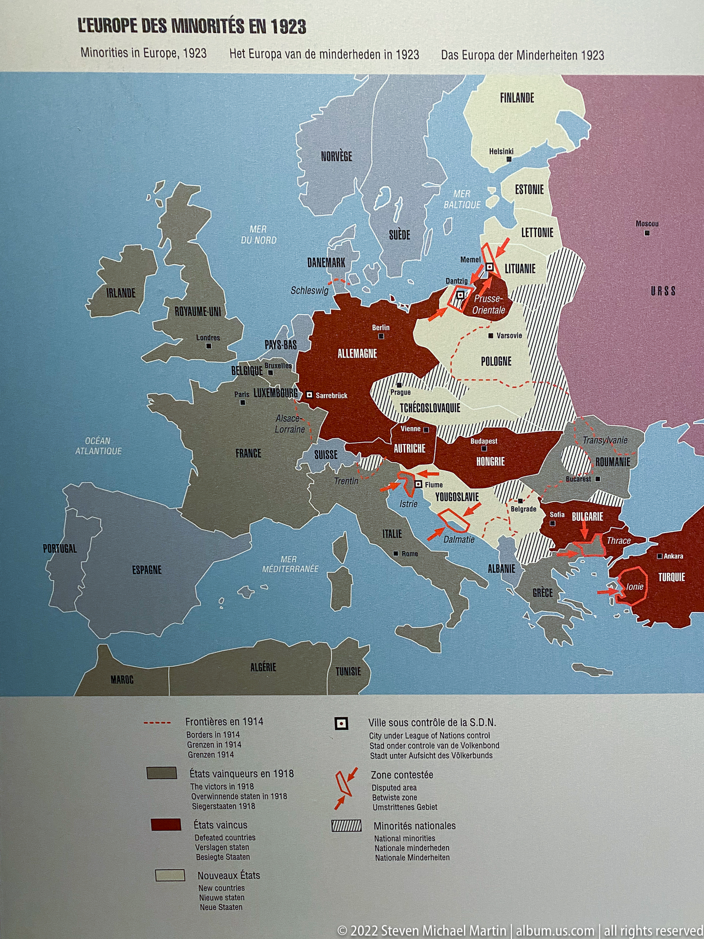
An interwar political map headed for Europe and minorities in 1923 uses contrasting colors, hatching, and arrows to represent frontiers, disputed areas, population movements, and minority regions. The dense overlay demonstrates the complexity of the postwar settlement in Central and Eastern Europe, where new states and borders did not neatly correspond to ethnic or linguistic communities.
Caption
An interwar political map headed for Europe and minorities in 1923 uses contrasting colors, hatching, and arrows to represent frontiers, disputed areas, population movements, and minority regions. The dense overlay demonstrates the complexity of the postwar settlement in Central and Eastern Europe, where new states and borders did not neatly correspond to ethnic or linguistic communities.
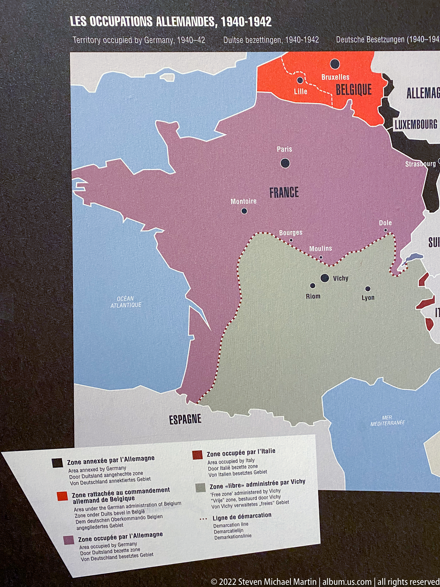
A map titled for German occupations from 1940 to 1942 shows France, Belgium, Luxembourg, and neighboring countries divided into differently administered zones. Color blocks distinguish annexed, occupied, and collaborationist or controlled territories, while the legend explains the varying forms of German rule. The map makes clear that occupation was not politically uniform across Western Europe.
Caption
A map titled for German occupations from 1940 to 1942 shows France, Belgium, Luxembourg, and neighboring countries divided into differently administered zones. Color blocks distinguish annexed, occupied, and collaborationist or controlled territories, while the legend explains the varying forms of German rule. The map makes clear that occupation was not politically uniform across Western Europe.
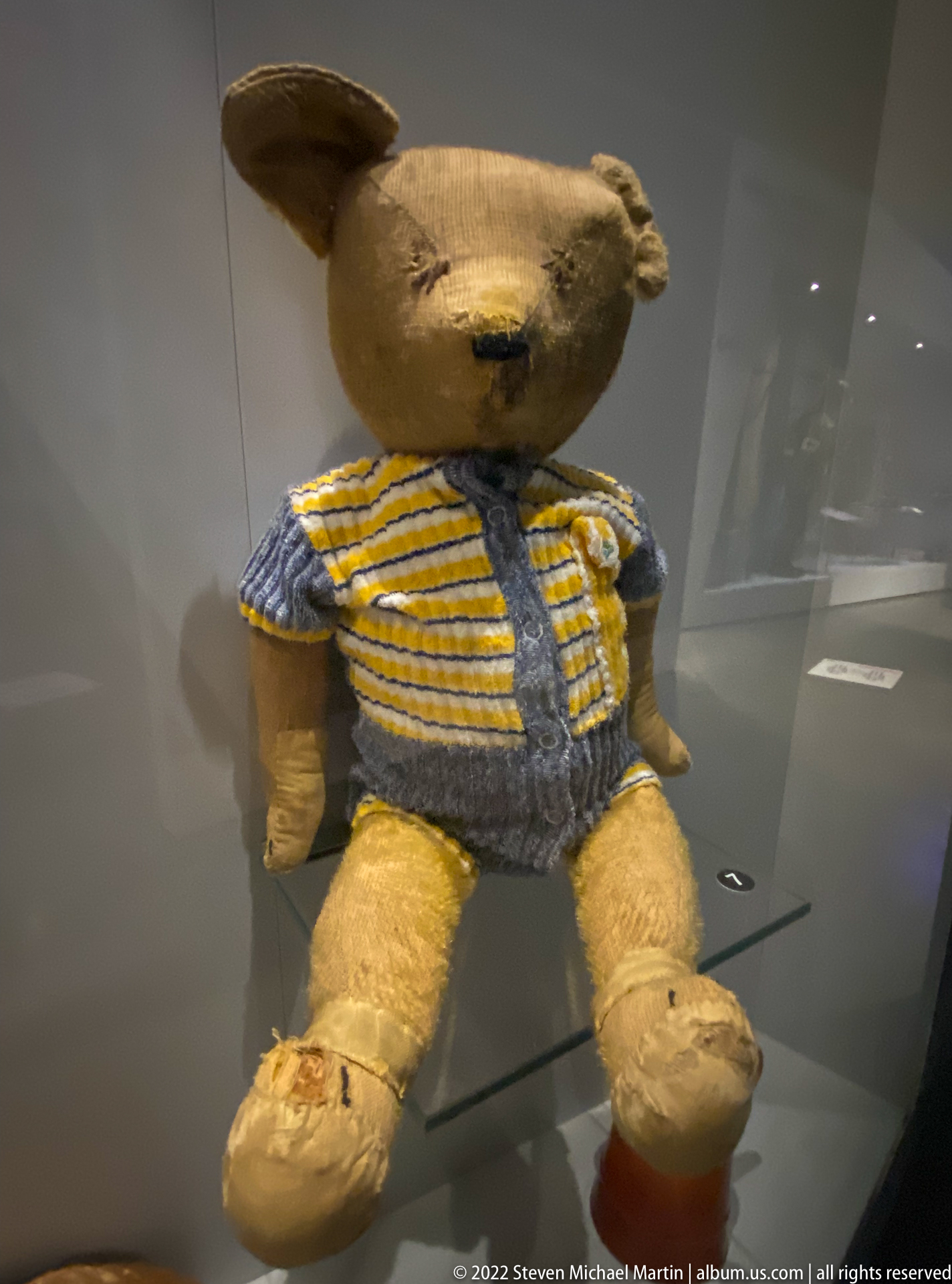
A well-worn teddy bear sits upright behind glass wearing a knitted striped garment, its flattened fur, repaired areas, and darkened wear marks revealing prolonged use. Displayed among wartime material, the toy introduces the scale of childhood and private life into a collection otherwise dominated by maps, weapons, and military equipment.
Caption
A well-worn teddy bear sits upright behind glass wearing a knitted striped garment, its flattened fur, repaired areas, and darkened wear marks revealing prolonged use. Displayed among wartime material, the toy introduces the scale of childhood and private life into a collection otherwise dominated by maps, weapons, and military equipment.
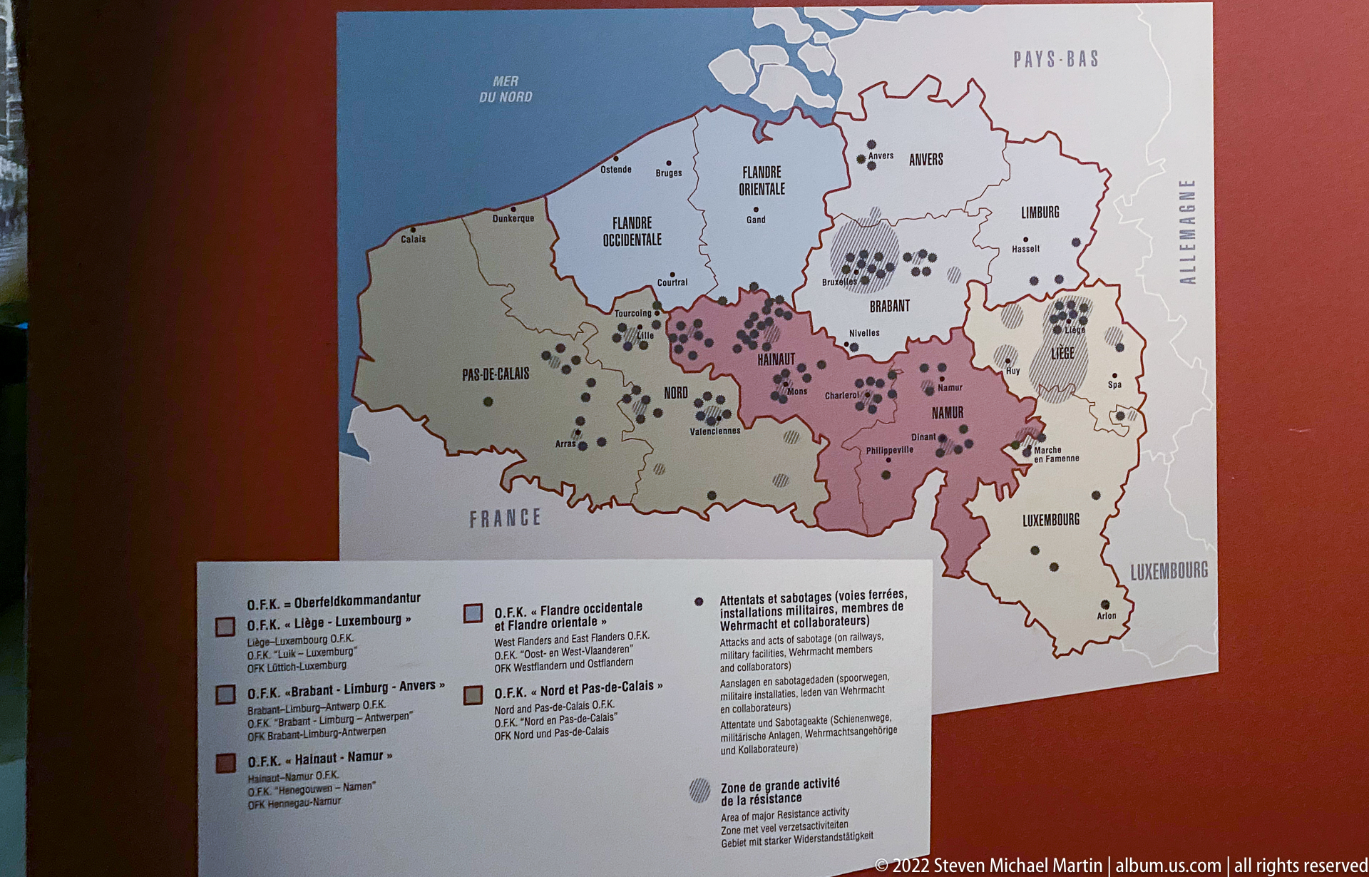
A museum map of Belgium uses provincial outlines, colored regions, and clusters of symbols to plot political or extremist activity across the country. The legend differentiates several organizations and zones of influence, turning a national map into a visual index of interwar political fragmentation. The concentration of marks in particular provinces makes regional variation immediately legible.
Caption
A museum map of Belgium uses provincial outlines, colored regions, and clusters of symbols to plot political or extremist activity across the country. The legend differentiates several organizations and zones of influence, turning a national map into a visual index of interwar political fragmentation. The concentration of marks in particular provinces makes regional variation immediately legible.

Two hand-decorated wartime souvenirs sit side by side in the museum case. One small box carries Allied flags and a painted Belgian lion, while the other bears the word “SOUVENIR,” a dedication “À MES CHERS PARENTS,” and the date 16 June 1945. Their intimate scale and handmade decoration contrast with the military hardware elsewhere in the collection.
Caption
Two hand-decorated wartime souvenirs sit side by side in the museum case. One small box carries Allied flags and a painted Belgian lion, while the other bears the word “SOUVENIR,” a dedication “À MES CHERS PARENTS,” and the date 16 June 1945. Their intimate scale and handmade decoration contrast with the military hardware elsewhere in the collection.

A black rotary field telephone rests on military maps marked with roads, place names, and colored annotations. The arrangement evokes command-and-control work in which telephone communications and paper mapping were used together to coordinate movements and report battlefield information. The handset, rotary dial, and map sheets form a compact material study of wartime staff operations.
Caption
A black rotary field telephone rests on military maps marked with roads, place names, and colored annotations. The arrangement evokes command-and-control work in which telephone communications and paper mapping were used together to coordinate movements and report battlefield information. The handset, rotary dial, and map sheets form a compact material study of wartime staff operations.

A large yellow-and-red road sign reading “BASTOGNE” fills the display case, its chipped and abraded surface preserving signs of long use and later handling. As an object, the sign condenses place-name and wartime memory into a single instantly recognizable word, making Bastogne itself the focal point rather than a specific battle scene or military artifact.
Caption
A large yellow-and-red road sign reading “BASTOGNE” fills the display case, its chipped and abraded surface preserving signs of long use and later handling. As an object, the sign condenses place-name and wartime memory into a single instantly recognizable word, making Bastogne itself the focal point rather than a specific battle scene or military artifact.
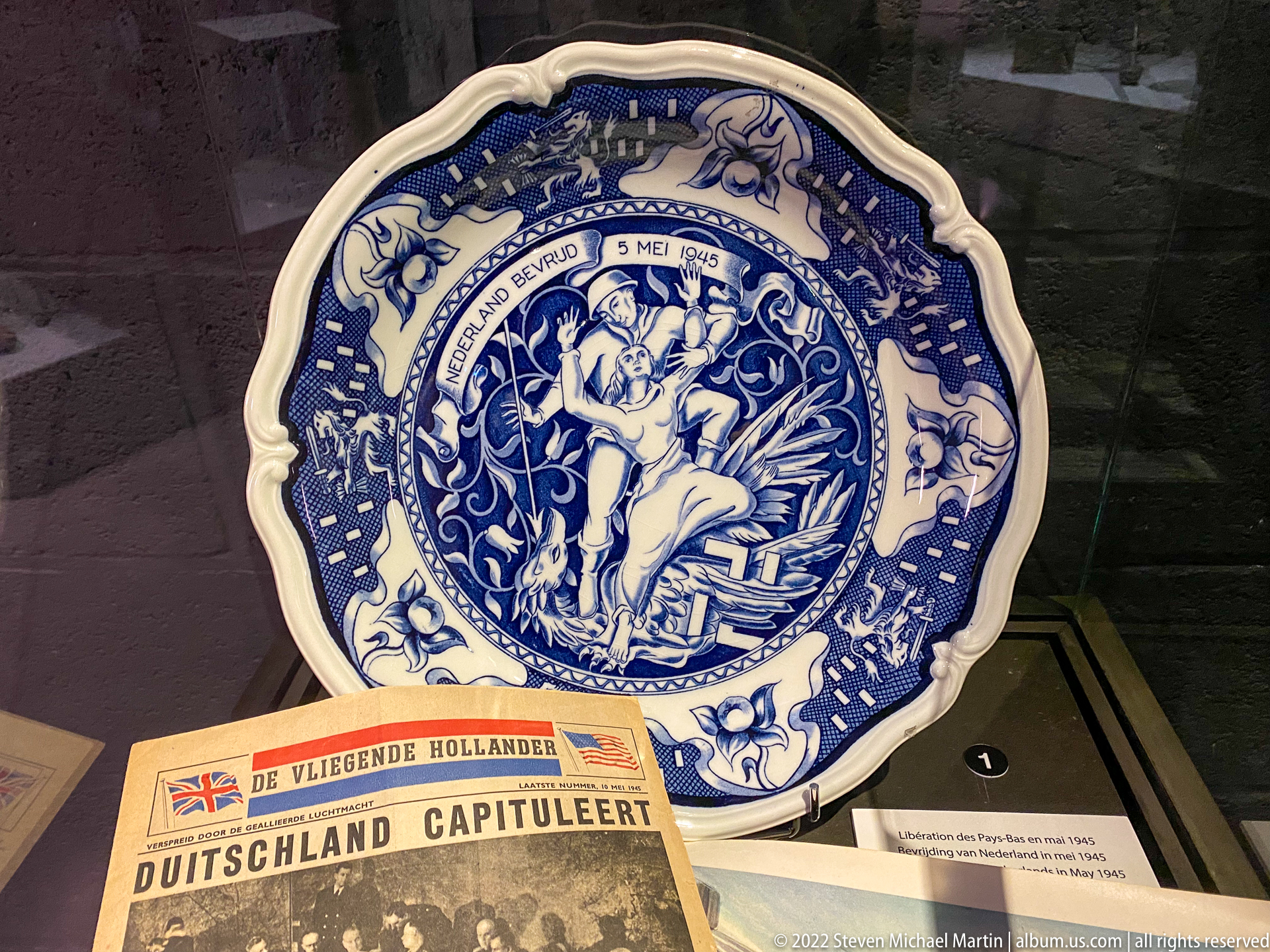
A blue-and-white commemorative plate dated “5 MEI 1945” is displayed with a Dutch newspaper announcing Germany's capitulation. The plate's allegorical central figure and ornate border transform the date of liberation into domestic commemorative art, while the newspaper beneath links that memory to the immediate news of German defeat.
Caption
A blue-and-white commemorative plate dated “5 MEI 1945” is displayed with a Dutch newspaper announcing Germany's capitulation. The plate's allegorical central figure and ornate border transform the date of liberation into domestic commemorative art, while the newspaper beneath links that memory to the immediate news of German defeat.

A heavy machine gun is displayed on a tall tripod, its long receiver, barrel assembly, ammunition-feed area, and robust mount clearly exposed for close inspection. The gallery backdrop incorporates wartime photographs and equipment, but the freestanding weapon remains the focal artifact. The presentation emphasizes its mechanical form and crew-served configuration rather than a reconstructed firing position.
Caption
A heavy machine gun is displayed on a tall tripod, its long receiver, barrel assembly, ammunition-feed area, and robust mount clearly exposed for close inspection. The gallery backdrop incorporates wartime photographs and equipment, but the freestanding weapon remains the focal artifact. The presentation emphasizes its mechanical form and crew-served configuration rather than a reconstructed firing position.

A heavily weathered three-blade aircraft propeller is mounted vertically as recovered wreckage, its blades bent, corroded, and stripped of much of their original finish. The damaged hub and uneven blade surfaces convey the violence of impact or long exposure, while the sparse display isolates the component as archaeological evidence of an aircraft rather than a restored machine.
Caption
A heavily weathered three-blade aircraft propeller is mounted vertically as recovered wreckage, its blades bent, corroded, and stripped of much of their original finish. The damaged hub and uneven blade surfaces convey the violence of impact or long exposure, while the sparse display isolates the component as archaeological evidence of an aircraft rather than a restored machine.
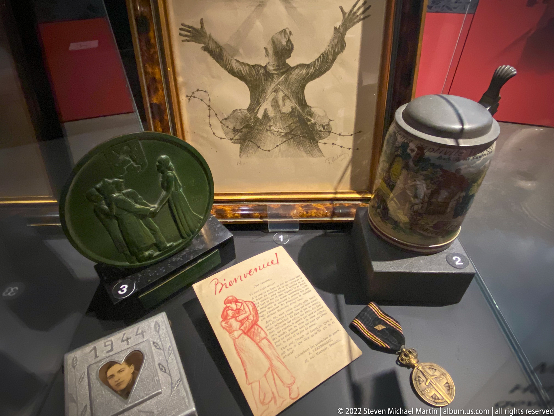
A display case gathers several small objects of personal memory: a framed drawing, a green relief plaque, a decorated ceramic stein, printed ephemera, a portrait photograph, and a medal on ribbon. Their mixed materials and intimate scale suggest remembrance through keepsakes rather than official military equipment, preserving the domestic and commemorative afterlife of wartime experience.
Caption
A display case gathers several small objects of personal memory: a framed drawing, a green relief plaque, a decorated ceramic stein, printed ephemera, a portrait photograph, and a medal on ribbon. Their mixed materials and intimate scale suggest remembrance through keepsakes rather than official military equipment, preserving the domestic and commemorative afterlife of wartime experience.
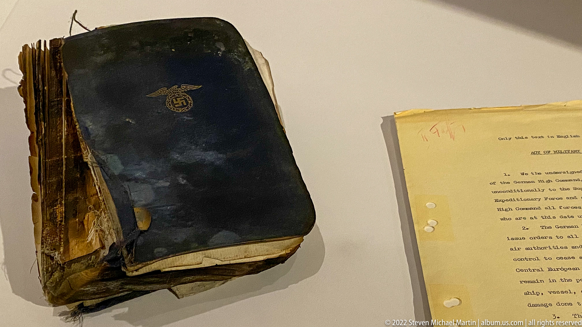
A charred and water-damaged bound volume lies open only by its fractured edges beside a typed sheet in the museum case. The blackened cover, warped pages, and severe material loss turn the book itself into evidence of destruction. The adjacent document appears to provide context, but its small text is not sufficiently legible here to establish the volume's exact identity or provenance.
Caption
A charred and water-damaged bound volume lies open only by its fractured edges beside a typed sheet in the museum case. The blackened cover, warped pages, and severe material loss turn the book itself into evidence of destruction. The adjacent document appears to provide context, but its small text is not sufficiently legible here to establish the volume's exact identity or provenance.
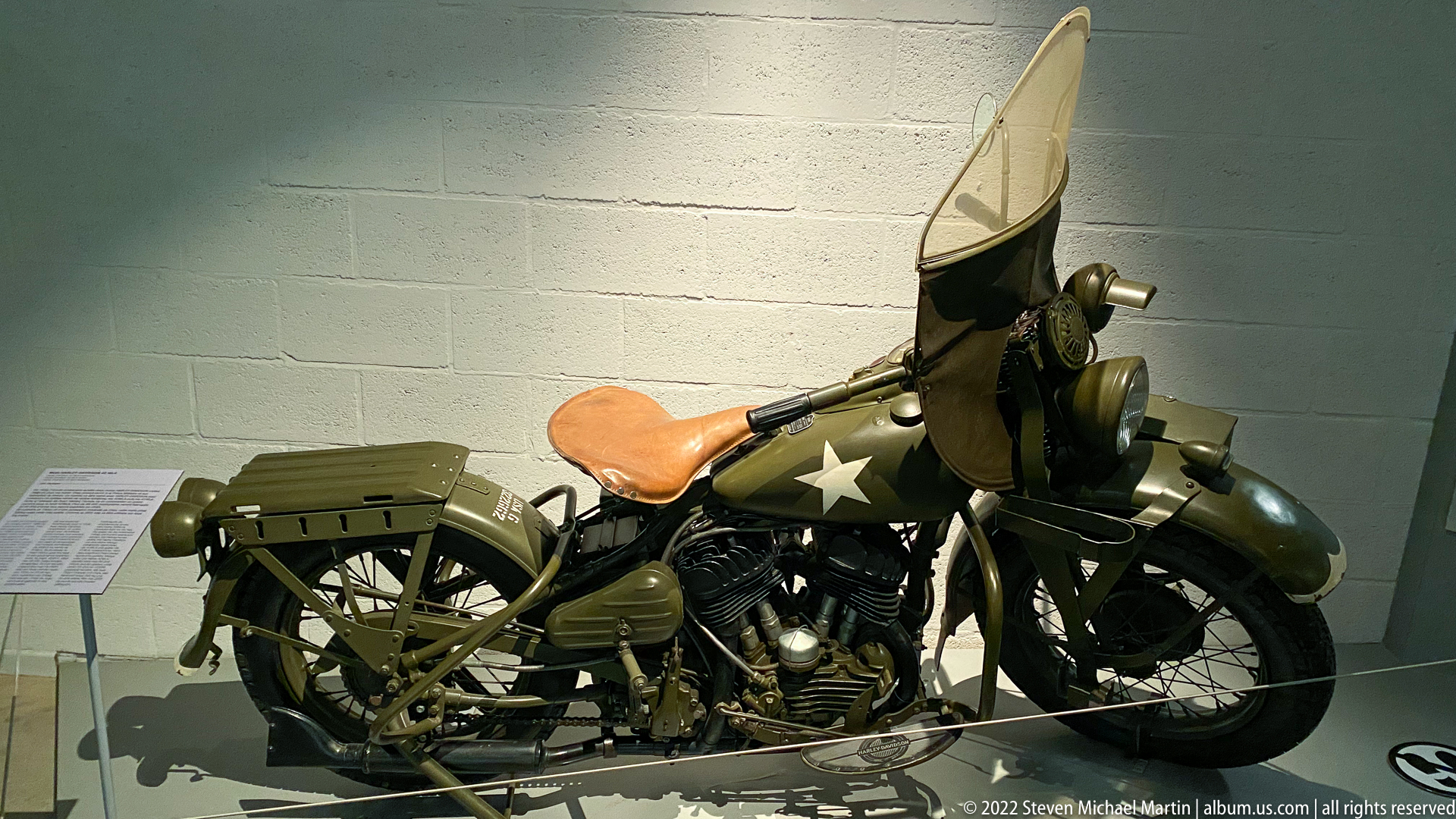
A restored olive-drab military motorcycle is displayed with a tall clear windshield, leather saddle, rear luggage rack, blackout-style lighting, and a white Allied star on the fuel tank. Its compact proportions and utilitarian fittings reflect the motorcycles used for dispatch, liaison, and military transport during the Second World War, while the gallery presentation allows the machine to be studied as a complete vehicle.
Caption
A restored olive-drab military motorcycle is displayed with a tall clear windshield, leather saddle, rear luggage rack, blackout-style lighting, and a white Allied star on the fuel tank. Its compact proportions and utilitarian fittings reflect the motorcycles used for dispatch, liaison, and military transport during the Second World War, while the gallery presentation allows the machine to be studied as a complete vehicle.

A bilingual map titled for soldiers who died in the Ardennes in 1944–1945 plots military cemeteries across Belgium, Luxembourg, France, Germany, and the Netherlands. Colored triangular symbols distinguish German, American, British, and other burial sites, while place names including Bastogne, Foy, Malmedy, Hamm, and Henri-Chapelle anchor the geography of wartime loss across the region.
Caption
A bilingual map titled for soldiers who died in the Ardennes in 1944–1945 plots military cemeteries across Belgium, Luxembourg, France, Germany, and the Netherlands. Colored triangular symbols distinguish German, American, British, and other burial sites, while place names including Bastogne, Foy, Malmedy, Hamm, and Henri-Chapelle anchor the geography of wartime loss across the region.
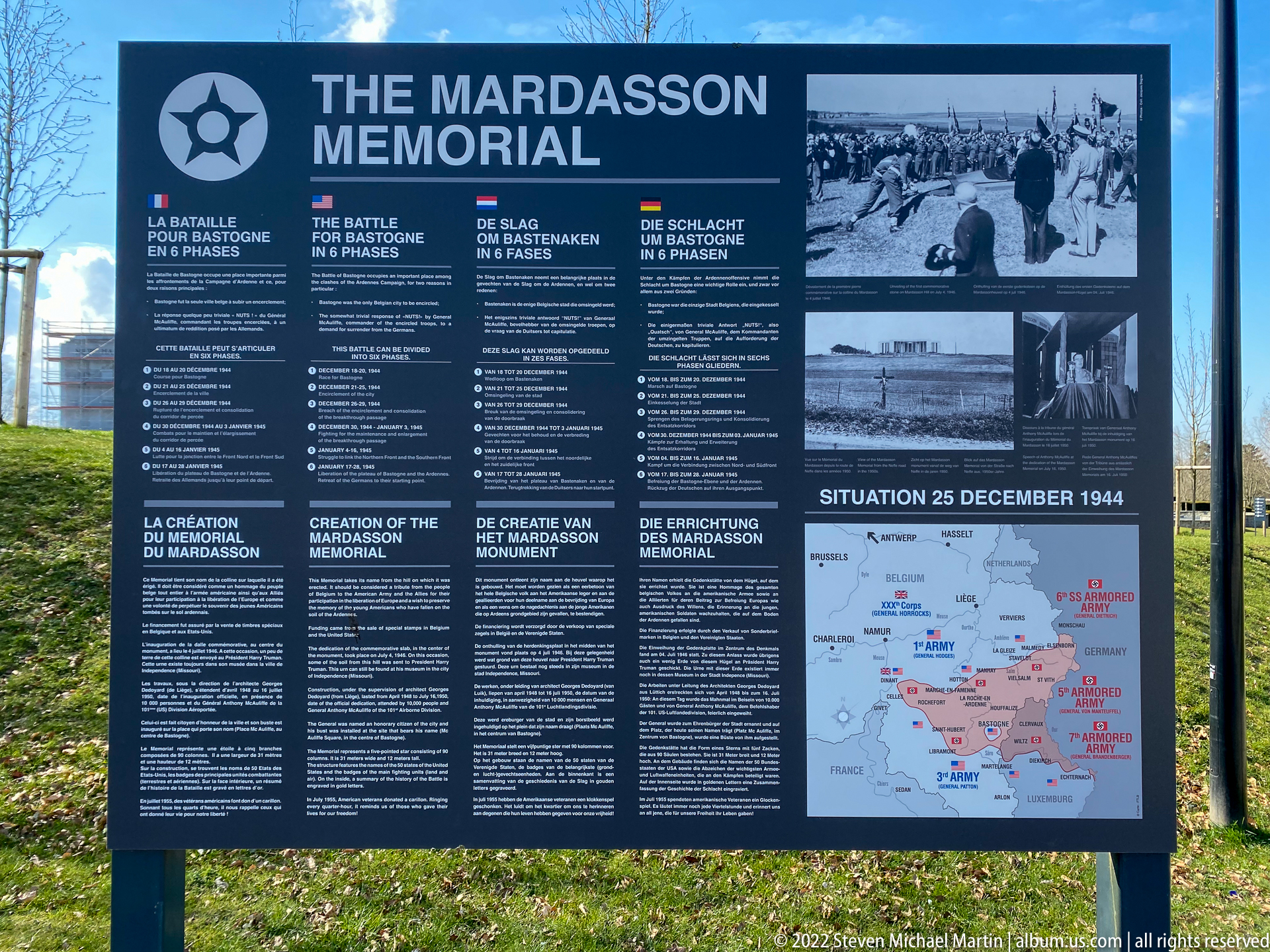
An outdoor interpretive panel titled “THE MARDASSON MEMORIAL” combines the monument’s history with a concise account of the Battle of the Bulge. Four language columns explain the memorial, while archival photographs and a map labeled “SITUATION 25 DECEMBER 1944” place the site within the wartime landscape. The panel links commemoration, military history, and the physical memorial grounds in a single presentation.
Caption
An outdoor interpretive panel titled “THE MARDASSON MEMORIAL” combines the monument’s history with a concise account of the Battle of the Bulge. Four language columns explain the memorial, while archival photographs and a map labeled “SITUATION 25 DECEMBER 1944” place the site within the wartime landscape. The panel links commemoration, military history, and the physical memorial grounds in a single presentation.

A detailed operational map labeled “SITUATION 25 DECEMBER 1944” shows the Battle of the Bulge front around Bastogne and the Ardennes. Blue and red formations identify opposing armies and corps, including U.S. Third Army units south of Bastogne and German armored armies to the east. The color-coded front lines and unit labels turn a complex battlefield situation into a legible snapshot of Christmas Day 1944.
Caption
A detailed operational map labeled “SITUATION 25 DECEMBER 1944” shows the Battle of the Bulge front around Bastogne and the Ardennes. Blue and red formations identify opposing armies and corps, including U.S. Third Army units south of Bastogne and German armored armies to the east. The color-coded front lines and unit labels turn a complex battlefield situation into a legible snapshot of Christmas Day 1944.
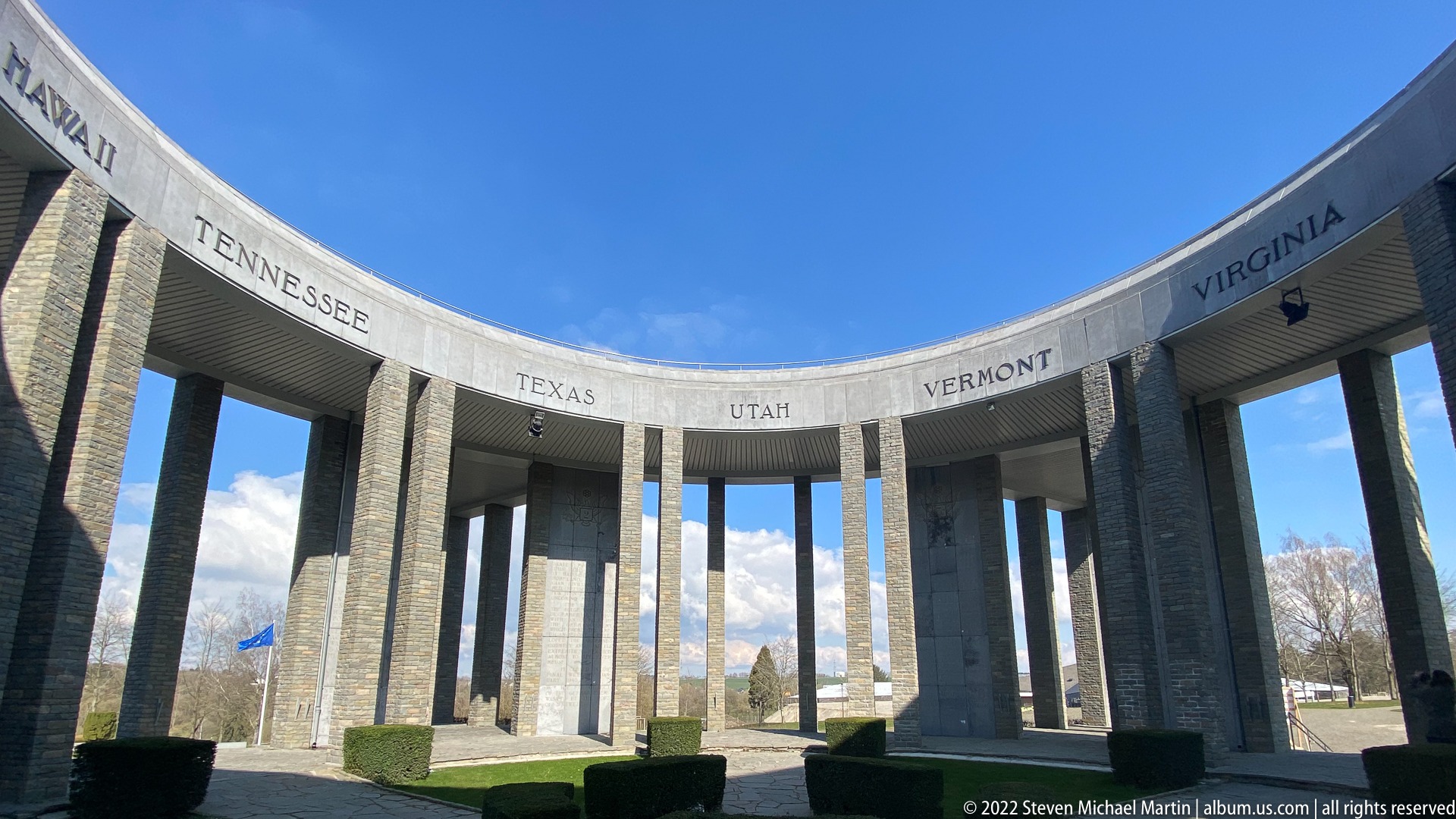
Inside the Mardasson Memorial, the curving stone colonnade opens dramatically to a clear blue sky. State names including Tennessee, Texas, Utah, Vermont, and Virginia are carved into the upper ring, while tall piers frame the surrounding landscape. The upward, wide-angle viewpoint makes the memorial’s circular geometry and repeated vertical supports the principal subjects of the composition.
Caption
Inside the Mardasson Memorial, the curving stone colonnade opens dramatically to a clear blue sky. State names including Tennessee, Texas, Utah, Vermont, and Virginia are carved into the upper ring, while tall piers frame the surrounding landscape. The upward, wide-angle viewpoint makes the memorial’s circular geometry and repeated vertical supports the principal subjects of the composition.

Tall rectangular piers and deep openings define an exterior entrance sector of the Mardasson Memorial. Across the entablature, state names including Ohio, Illinois, Indiana, Iowa, Kansas, and Kentucky are carved in large capitals. Steps and metal railings lead toward the interior, while the oblique viewpoint reveals both the monument’s monumental mass and the rhythmic spacing of its colonnade.
Caption
Tall rectangular piers and deep openings define an exterior entrance sector of the Mardasson Memorial. Across the entablature, state names including Ohio, Illinois, Indiana, Iowa, Kansas, and Kentucky are carved in large capitals. Steps and metal railings lead toward the interior, while the oblique viewpoint reveals both the monument’s monumental mass and the rhythmic spacing of its colonnade.