Martigny – Switzerland
Martigny lies in the Rhône Valley in southwestern Switzerland where several important alpine routes converge. For centuries the town served as a crossroads between northern Europe and Italy through passes such as the Great St. Bernard Pass.
The settlement has ancient origins dating back to the Roman city of Octodurus, and archaeological remains from this period can still be seen in the area. Today Martigny is known for its historic architecture, cultural institutions, and its role as a gateway to the surrounding alpine valleys.
The town’s location within the Rhône Valley places it at an important junction connecting the Alpine regions of Switzerland, France, and Italy.

A descending path passes between massive stone walls toward the open arena of Martigny’s amphitheatre. Timber handrails and grass-paver surfacing mark the modern visitor route, while the narrowing masonry corridor conveys the controlled passage through the ancient monument’s perimeter.
Caption
A descending path passes between massive stone walls toward the open arena of Martigny’s amphitheatre. Timber handrails and grass-paver surfacing mark the modern visitor route, while the narrowing masonry corridor conveys the controlled passage through the ancient monument’s perimeter.

A sharply pyramidal Alpine summit rises above darker, rugged lower ridges, its upper slopes heavily mantled in snow beneath a clear blue sky. Sunlight isolates the bright peak from the shaded foreground mountains, while wisps of cloud cling to the adjoining ridge. Seen from the Martigny area, the composition shifts the portfolio from cultivated valley slopes to the high-mountain landscape surrounding them.
Caption
A sharply pyramidal Alpine summit rises above darker, rugged lower ridges, its upper slopes heavily mantled in snow beneath a clear blue sky. Sunlight isolates the bright peak from the shaded foreground mountains, while wisps of cloud cling to the adjoining ridge. Seen from the Martigny area, the composition shifts the portfolio from cultivated valley slopes to the high-mountain landscape surrounding them.
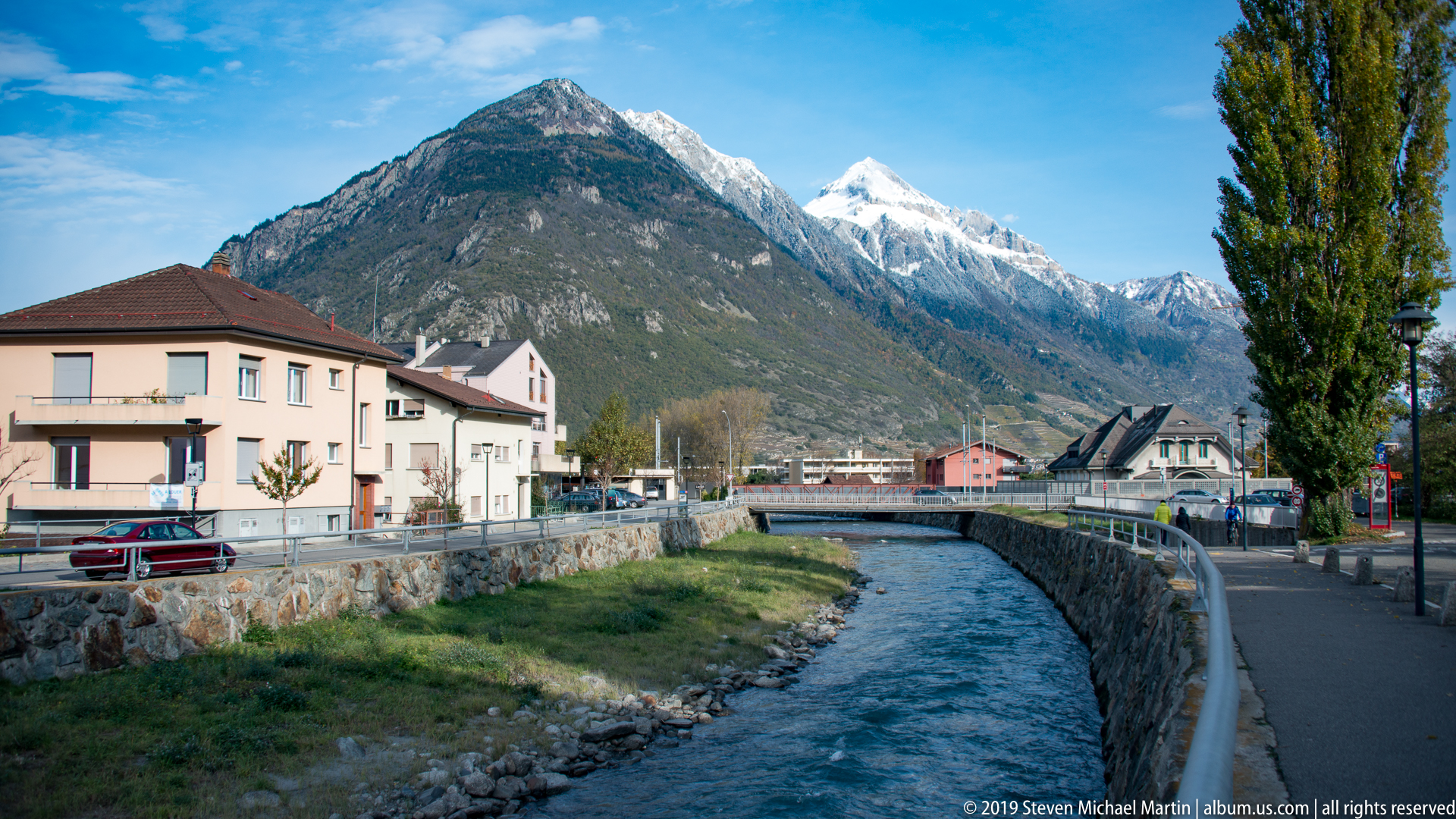
A stone-lined river channel runs through Martigny toward steep Alpine mountains, with houses, a road, and a bridge defining the urban edges. The straightened watercourse creates a strong central perspective, linking the town’s built environment to the dramatic valley walls and snow-touched peaks beyond.
Caption
A stone-lined river channel runs through Martigny toward steep Alpine mountains, with houses, a road, and a bridge defining the urban edges. The straightened watercourse creates a strong central perspective, linking the town’s built environment to the dramatic valley walls and snow-touched peaks beyond.

A colored reconstruction imagines Martigny’s Roman amphitheatre in use, with spectators filling the elliptical seating around the arena and ancillary buildings spread across the valley floor beyond. The drawing makes the monument’s enclosed arena, tiered cavea, entrances, and mountain setting legible at a glance.
Caption
A colored reconstruction imagines Martigny’s Roman amphitheatre in use, with spectators filling the elliptical seating around the arena and ancillary buildings spread across the valley floor beyond. The drawing makes the monument’s enclosed arena, tiered cavea, entrances, and mountain setting legible at a glance.

A bird’s-eye reconstruction presents the gridded Roman settlement at Martigny as a dense complex of streets, insulae, public buildings, and surrounding cultivated land. The elevated perspective clarifies the planned urban pattern and its relationship to the broad Alpine valley and steep mountain slopes.
Caption
A bird’s-eye reconstruction presents the gridded Roman settlement at Martigny as a dense complex of streets, insulae, public buildings, and surrounding cultivated land. The elevated perspective clarifies the planned urban pattern and its relationship to the broad Alpine valley and steep mountain slopes.

Low archaeological walls extend through a grassy park beneath mature trees, presenting the Roman remains as part of a landscaped public site. This wider contextual view emphasizes the modest surviving height of the masonry and its relationship to paths, lawns, and wooded Alpine slopes rather than isolating an individual structure.
Caption
Low archaeological walls extend through a grassy park beneath mature trees, presenting the Roman remains as part of a landscaped public site. This wider contextual view emphasizes the modest surviving height of the masonry and its relationship to paths, lawns, and wooded Alpine slopes rather than isolating an individual structure.

Bands of vineyard terraces contour a steep slope near Martigny, their stone-supported plots and narrow access tracks forming a dense agricultural pattern across the hillside. Autumn foliage shifts from green to yellow and ochre, while a small dark-roofed vineyard structure provides a point of scale among the vines. The view records the close adaptation of viticulture to sharply inclined Alpine terrain.
Caption
Bands of vineyard terraces contour a steep slope near Martigny, their stone-supported plots and narrow access tracks forming a dense agricultural pattern across the hillside. Autumn foliage shifts from green to yellow and ochre, while a small dark-roofed vineyard structure provides a point of scale among the vines. The view records the close adaptation of viticulture to sharply inclined Alpine terrain.

Rectangular and irregular vineyard parcels spread across the slope near Martigny, separated by retaining walls, tracks, and changes in planting orientation. Green rows alternate with vines turning yellow in autumn, creating a patchwork that reveals the small-scale division of the cultivated hillside. Scattered utility buildings and vineyard shelters punctuate the terraces without interrupting the dominant geometry of the vines.
Caption
Rectangular and irregular vineyard parcels spread across the slope near Martigny, separated by retaining walls, tracks, and changes in planting orientation. Green rows alternate with vines turning yellow in autumn, creating a patchwork that reveals the small-scale division of the cultivated hillside. Scattered utility buildings and vineyard shelters punctuate the terraces without interrupting the dominant geometry of the vines.

A broad section of cultivated hillside near Martigny shows vineyards arranged in long horizontal and diagonal bands, their autumn colors ranging from muted green to vivid yellow. Pale retaining walls and access routes divide the slope into distinct parcels, while a small cluster of trees interrupts the otherwise repetitive vine rows. The wider viewpoint emphasizes the scale and engineered organization of hillside viticulture.
Caption
A broad section of cultivated hillside near Martigny shows vineyards arranged in long horizontal and diagonal bands, their autumn colors ranging from muted green to vivid yellow. Pale retaining walls and access routes divide the slope into distinct parcels, while a small cluster of trees interrupts the otherwise repetitive vine rows. The wider viewpoint emphasizes the scale and engineered organization of hillside viticulture.

An outdoor interpretation panel combines French text, archival excavation photographs, site plans, and reconstruction drawings to explain the archaeological remains of Roman Martigny. The dense graphic layout places historical images beside mapped structures, giving visitors a visual guide to how the ancient settlement was uncovered and understood.
Caption
An outdoor interpretation panel combines French text, archival excavation photographs, site plans, and reconstruction drawings to explain the archaeological remains of Roman Martigny. The dense graphic layout places historical images beside mapped structures, giving visitors a visual guide to how the ancient settlement was uncovered and understood.

The cylindrical stone keep and curtain wall of Château de la Bâtiaz rise directly from a rocky spur above Martigny. Seen from below, the compact fortified enclosure follows the uneven ridge while the round tower dominates the skyline, making the castle’s defensive relationship to the steep terrain especially clear.
Caption
The cylindrical stone keep and curtain wall of Château de la Bâtiaz rise directly from a rocky spur above Martigny. Seen from below, the compact fortified enclosure follows the uneven ridge while the round tower dominates the skyline, making the castle’s defensive relationship to the steep terrain especially clear.

The red-gabled Barryland building in Martigny presents a modern visitor entrance beneath the prominently displayed Barryland emblem and script sign. Stone piers, broad roof overhangs, terrace seating, and alpine slopes behind the structure place the Saint Bernard attraction within its mountain-valley setting.
Caption
The red-gabled Barryland building in Martigny presents a modern visitor entrance beneath the prominently displayed Barryland emblem and script sign. Stone piers, broad roof overhangs, terrace seating, and alpine slopes behind the structure place the Saint Bernard attraction within its mountain-valley setting.

A detailed plan labeled “Martigny Forum Claudii Vallensium / Plan Archéologique” maps excavated insulae, streets, public spaces, and associated structures of the Roman settlement. Modern roads and property lines remain visible around the archaeological footprint, showing how the ancient urban fabric sits within present-day Martigny.
Caption
A detailed plan labeled “Martigny Forum Claudii Vallensium / Plan Archéologique” maps excavated insulae, streets, public spaces, and associated structures of the Roman settlement. Modern roads and property lines remain visible around the archaeological footprint, showing how the ancient urban fabric sits within present-day Martigny.

A low masonry wall of the Roman amphitheatre runs across a grassy embankment, interrupted by a small rectangular doorway secured with a metal grille. Weathered stone and pale wall surfaces reveal the surviving perimeter at close range, while the rising ground behind indicates the monument’s earth-supported seating form.
Caption
A low masonry wall of the Roman amphitheatre runs across a grassy embankment, interrupted by a small rectangular doorway secured with a metal grille. Weathered stone and pale wall surfaces reveal the surviving perimeter at close range, while the rising ground behind indicates the monument’s earth-supported seating form.
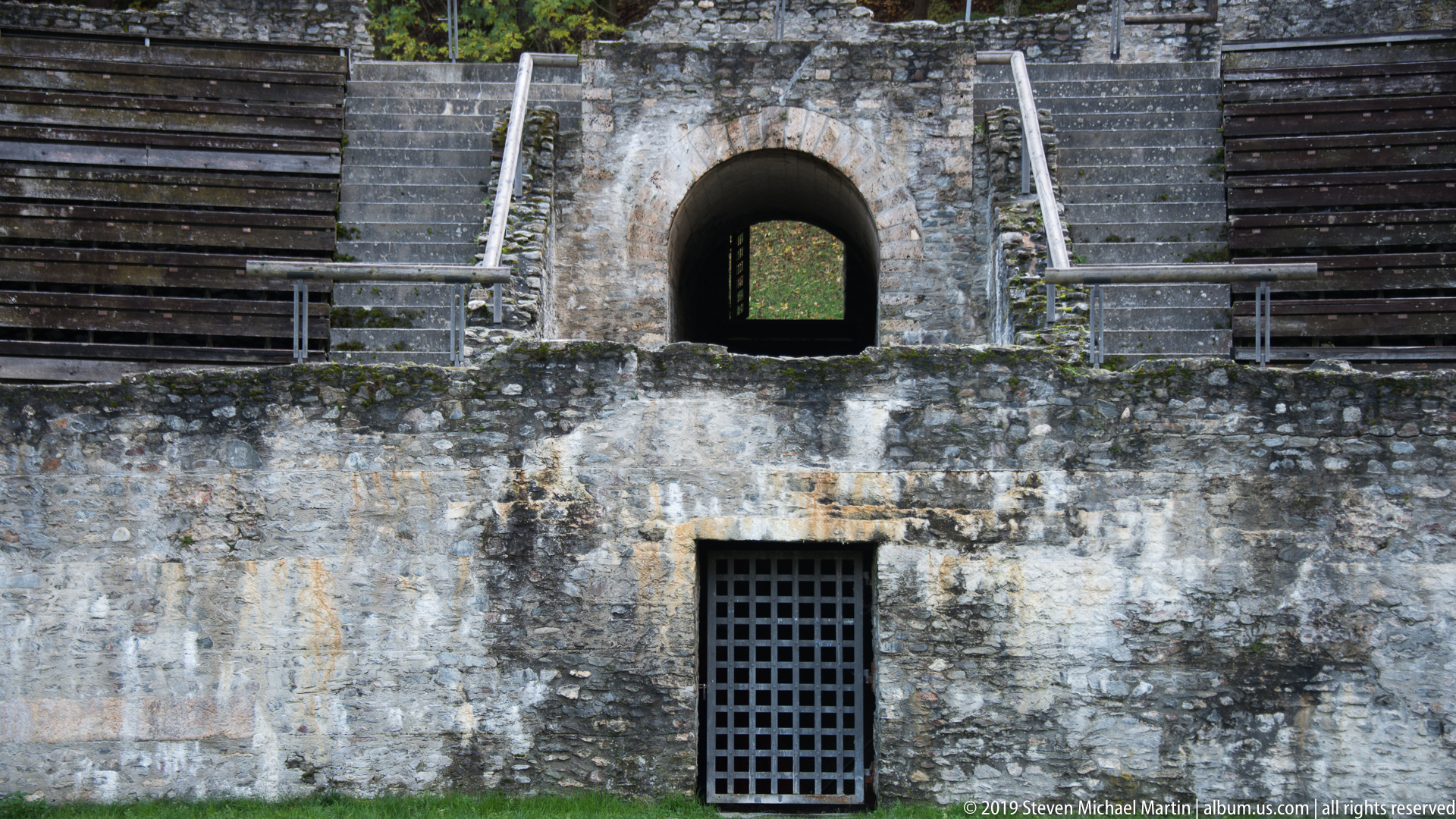
An arched passage pierces the upper masonry of Martigny’s amphitheatre above a barred rectangular opening at arena level. Modern stepped seating rises symmetrically on either side, emphasizing the layered relationship between surviving Roman fabric and the restored access and viewing areas.
Caption
An arched passage pierces the upper masonry of Martigny’s amphitheatre above a barred rectangular opening at arena level. Modern stepped seating rises symmetrically on either side, emphasizing the layered relationship between surviving Roman fabric and the restored access and viewing areas.

A heavy metal grille closes a rectangular opening in the rough stonework of Martigny’s amphitheatre. The close view isolates contrasting masonry textures—irregular rubble construction beside more regular cut stone—making this surviving access point a study in the monument’s fabric rather than its overall form.
Caption
A heavy metal grille closes a rectangular opening in the rough stonework of Martigny’s amphitheatre. The close view isolates contrasting masonry textures—irregular rubble construction beside more regular cut stone—making this surviving access point a study in the monument’s fabric rather than its overall form.
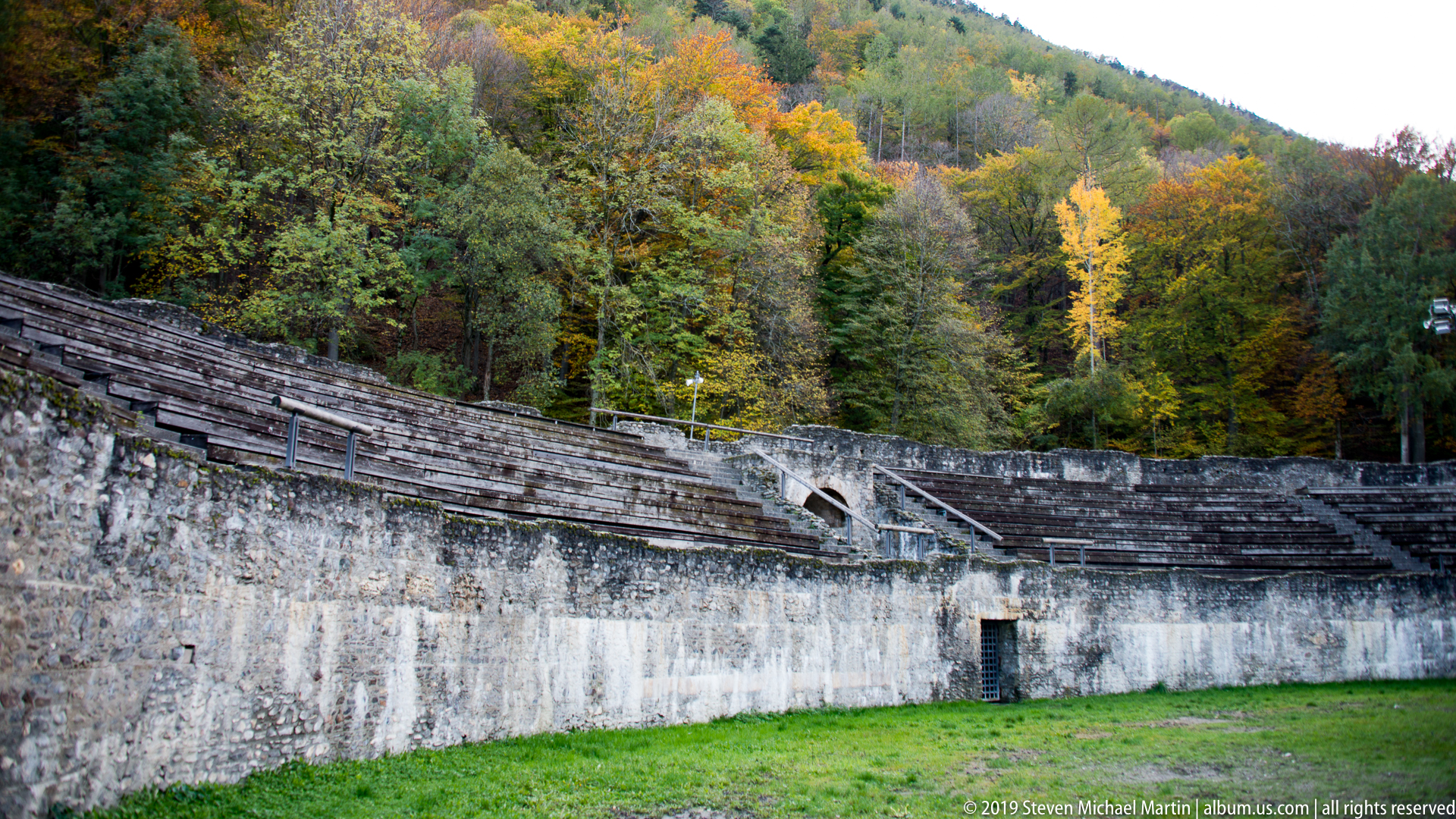
Curving tiers of the amphitheatre sweep across the frame above the high arena wall, backed by autumn woodland on the hillside. This oblique view emphasizes the long arc of the cavea and the monument’s placement against the wooded slope rather than the arena’s full elliptical plan.
Caption
Curving tiers of the amphitheatre sweep across the frame above the high arena wall, backed by autumn woodland on the hillside. This oblique view emphasizes the long arc of the cavea and the monument’s placement against the wooded slope rather than the arena’s full elliptical plan.
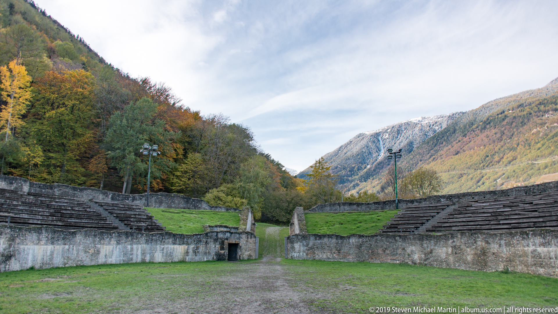
From the arena floor, the restored seating of Martigny’s amphitheatre opens toward a dramatic Alpine valley. Opposing banks of stepped seats frame the central entrance axis, while wooded slopes and pale mountain faces beyond show how closely the archaeological site is integrated with its natural setting.
Caption
From the arena floor, the restored seating of Martigny’s amphitheatre opens toward a dramatic Alpine valley. Opposing banks of stepped seats frame the central entrance axis, while wooded slopes and pale mountain faces beyond show how closely the archaeological site is integrated with its natural setting.

Seen from just outside the enclosure, thick masonry flanks the entrance leading into Martigny’s amphitheatre arena. The central opening aligns with the opposite seating and valley beyond, while grass-covered banks and autumn woods soften the surviving stonework and reveal the monument’s partly earth-built profile.
Caption
Seen from just outside the enclosure, thick masonry flanks the entrance leading into Martigny’s amphitheatre arena. The central opening aligns with the opposite seating and valley beyond, while grass-covered banks and autumn woods soften the surviving stonework and reveal the monument’s partly earth-built profile.

A large interpretive panel combines a plan of the amphitheatre, a map of the surrounding archaeological area, coin images, and multilingual explanatory text. The display situates the monument within Roman Martigny while using excavated material and diagrams to connect the surviving ruins with their ancient context.
Caption
A large interpretive panel combines a plan of the amphitheatre, a map of the surrounding archaeological area, coin images, and multilingual explanatory text. The display situates the monument within Roman Martigny while using excavated material and diagrams to connect the surviving ruins with their ancient context.

A measured plan diagrams the amphitheatre as an elongated ellipse, labeling the arena, cavea, promenades, entrances, and access ramps. Presented as a clean architectural drawing, it explains the circulation and seating geometry that can be difficult to read from ground level among the surviving walls and restored tiers.
Caption
A measured plan diagrams the amphitheatre as an elongated ellipse, labeling the arena, cavea, promenades, entrances, and access ramps. Presented as a clean architectural drawing, it explains the circulation and seating geometry that can be difficult to read from ground level among the surviving walls and restored tiers.

Six black-and-white archaeological photographs document excavated walls, trenches, and structural remains at Martigny from different viewpoints. Arranged as a reference sequence on an interpretation panel, the images preserve stages of investigation and expose foundations that are less readily understood in the landscaped site today.
Caption
Six black-and-white archaeological photographs document excavated walls, trenches, and structural remains at Martigny from different viewpoints. Arranged as a reference sequence on an interpretation panel, the images preserve stages of investigation and expose foundations that are less readily understood in the landscaped site today.

A monochrome line drawing reconstructs a compact fortified enclosure with perimeter palisade or wall, central buildings, and a prominent tower-like feature. The elevated viewpoint is interpretive rather than archaeological evidence itself, offering visitors a visual hypothesis for the form and organization of an earlier settlement phase.
Caption
A monochrome line drawing reconstructs a compact fortified enclosure with perimeter palisade or wall, central buildings, and a prominent tower-like feature. The elevated viewpoint is interpretive rather than archaeological evidence itself, offering visitors a visual hypothesis for the form and organization of an earlier settlement phase.

The plan of Forum Claudii Vallensium lays out Martigny’s Roman urban quarter as a grid of insulae and streets, with the amphitheatre plotted separately beyond the main blocks. Labels identify excavated areas and public structures, allowing the viewer to understand the spatial relationship between the town center and its entertainment monument.
Caption
The plan of Forum Claudii Vallensium lays out Martigny’s Roman urban quarter as a grid of insulae and streets, with the amphitheatre plotted separately beyond the main blocks. Labels identify excavated areas and public structures, allowing the viewer to understand the spatial relationship between the town center and its entertainment monument.

The steep red gable of Barryland fills the frame, carrying the attraction’s Saint Bernard emblem and large white script name. Faint lettering below refers to the museum and dogs of Saint Bernard, while the tiled roof and surrounding trees give this view a tighter architectural focus than the broader entrance photograph.
Caption
The steep red gable of Barryland fills the frame, carrying the attraction’s Saint Bernard emblem and large white script name. Faint lettering below refers to the museum and dogs of Saint Bernard, while the tiled roof and surrounding trees give this view a tighter architectural focus than the broader entrance photograph.

Rows of vines turn gold across steep terraces cut into the rocky mountainside near Martigny. Dry-stone retaining walls divide the slope into narrow horizontal bands, demonstrating how viticulture is fitted to the abrupt Alpine terrain; a small vineyard shelter sits among the lower rows.
Caption
Rows of vines turn gold across steep terraces cut into the rocky mountainside near Martigny. Dry-stone retaining walls divide the slope into narrow horizontal bands, demonstrating how viticulture is fitted to the abrupt Alpine terrain; a small vineyard shelter sits among the lower rows.

Narrow vineyard terraces step across a steep, rocky hillside, their autumn foliage forming bright horizontal bands against gray stone and grass. The compressed telephoto view stresses the engineering of the cultivated slope—small plots, retaining walls, and access lines—more than the broader valley landscape.
Caption
Narrow vineyard terraces step across a steep, rocky hillside, their autumn foliage forming bright horizontal bands against gray stone and grass. The compressed telephoto view stresses the engineering of the cultivated slope—small plots, retaining walls, and access lines—more than the broader valley landscape.

The round keep of Château de la Bâtiaz stands against a snow-covered Alpine peak, its pale masonry sharply separated from the blue sky. Lower curtain walls and rocky slopes anchor the fortress in the foreground, while the compressed viewpoint visually links Martigny’s medieval stronghold with the high mountains surrounding the Rhône valley.
Caption
The round keep of Château de la Bâtiaz stands against a snow-covered Alpine peak, its pale masonry sharply separated from the blue sky. Lower curtain walls and rocky slopes anchor the fortress in the foreground, while the compressed viewpoint visually links Martigny’s medieval stronghold with the high mountains surrounding the Rhône valley.

Château de la Bâtiaz occupies a rocky ridge above Martigny, with its cylindrical keep silhouetted against a snow-streaked mountain. Trees partly screen the lower fortifications, producing a more distant landscape view that emphasizes the castle’s commanding elevation and the dramatic Alpine topography around it.
Caption
Château de la Bâtiaz occupies a rocky ridge above Martigny, with its cylindrical keep silhouetted against a snow-streaked mountain. Trees partly screen the lower fortifications, producing a more distant landscape view that emphasizes the castle’s commanding elevation and the dramatic Alpine topography around it.

Château de la Bâtiaz crowns a bare gray rock outcrop, its cylindrical keep and adjoining defensive wall rising above the cliff edge. The low-angle composition minimizes the town below and concentrates attention on the fortress’s masonry mass, exposed geology, and strategic placement over the Martigny valley.
Caption
Château de la Bâtiaz crowns a bare gray rock outcrop, its cylindrical keep and adjoining defensive wall rising above the cliff edge. The low-angle composition minimizes the town below and concentrates attention on the fortress’s masonry mass, exposed geology, and strategic placement over the Martigny valley.

A roofed wooden bridge spans the river in the foreground while Château de la Bâtiaz rises on the rocky hillside above. Houses clustered along the channel establish the urban scale between bridge and fortress, creating a layered view of Martigny’s river corridor and medieval landmark.
Caption
A roofed wooden bridge spans the river in the foreground while Château de la Bâtiaz rises on the rocky hillside above. Houses clustered along the channel establish the urban scale between bridge and fortress, creating a layered view of Martigny’s river corridor and medieval landmark.

A close view of Château de la Bâtiaz isolates its cylindrical keep above a broad stone curtain wall pierced by narrow openings. Flags fly from the tower, while the rocky, scrub-covered slope below reinforces the fortress’s elevated position and exposes the texture and irregularity of its historic masonry.
Caption
A close view of Château de la Bâtiaz isolates its cylindrical keep above a broad stone curtain wall pierced by narrow openings. Flags fly from the tower, while the rocky, scrub-covered slope below reinforces the fortress’s elevated position and exposes the texture and irregularity of its historic masonry.

The dark roofline of a covered wooden bridge crosses the lower frame beneath Château de la Bâtiaz, whose round keep dominates the hillside above. Seasonal decorations hang along the bridge siding, adding a human-scale foreground to the steep rock face and fortified silhouette beyond.
Caption
The dark roofline of a covered wooden bridge crosses the lower frame beneath Château de la Bâtiaz, whose round keep dominates the hillside above. Seasonal decorations hang along the bridge siding, adding a human-scale foreground to the steep rock face and fortified silhouette beyond.

A tight view across the hillside reduces Martigny’s vineyards to a patterned field of gold, rust, and green. Narrow tracks and pale stone retaining lines divide the vines into angular plots, revealing the intricate geometry created by cultivation on steep terrain during the autumn season.
Caption
A tight view across the hillside reduces Martigny’s vineyards to a patterned field of gold, rust, and green. Narrow tracks and pale stone retaining lines divide the vines into angular plots, revealing the intricate geometry created by cultivation on steep terrain during the autumn season.

Foreground branches and a dark lower ridge frame a snow-covered Alpine summit beyond Martigny, concentrating attention on the peak's steep triangular profile. Bright sunlight catches the upper snowfields while the nearer rock faces remain largely in shadow, producing a strong separation of distance and elevation. Thin cloud brushes the ridge to the right, adding a transient atmospheric detail to the high-mountain view.
Caption
Foreground branches and a dark lower ridge frame a snow-covered Alpine summit beyond Martigny, concentrating attention on the peak's steep triangular profile. Bright sunlight catches the upper snowfields while the nearer rock faces remain largely in shadow, producing a strong separation of distance and elevation. Thin cloud brushes the ridge to the right, adding a transient atmospheric detail to the high-mountain view.